Benoy geodata
Benoy (Logone Occidental) is a populated place; located in Chad in Africa/Ndjamena (GMT+1) time zone. With population of 15,717 people, there are 21 cities with bigger population in this country. Compared to other cities in Chad, 85.1% of cities are located further ↑North; 61.7% of cities are located further →East and 66% of cities have lower elevation than Benoy. Note1


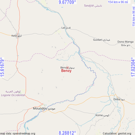
Benoy GPS coordinates[2]
8° 58' 59.772" North, 16° 19' 11.676" East
| Map corner | latitude | longitude |
|---|---|---|
| Upper-left | 9.67709°, | 15.61679° |
| Center: | 8.98327°, | 16.31991° |
| Lower-right: | 8.28812°, | 17.02304° |
| Map W x H: | 154.4×154.4 km | = 95.9×95.9mi |
| max Lat: | 21.8375° ⇑85.1% North |
| Benoy: | 8.98327° |
| min Lat: | ⇓14.9% South 8.26681° |
| min Long | Benoy | max Long |
| 14.1539° | 16.31991° | 22.84308° |
| W 38.3%⇐ | ⇒61.7% E |
Elevation
Elevation of Benoy is 417 m = 1368 ft, and this is 20.3 m = 67 ft below average elevation for this country.
| Max E: |
1046 m = 3432 ft | 34% |
| Avg. | 437.3 m = 1435 ft | |
| Benoy | 417 m = 1368 ft | |
Min E: |
242 m = 794 ft | 66% |
See also: Chad elevation on elevation.city.
Geographical zone
Benoy is located in North Torrid zone (between Equator and Tropic of Cancer). Distance of Equator is 998.8 km =620.6 mi to South.| Distance of | km | miles | from Benoy |
|---|---|---|---|
| North Pole | 9008.2 | 5597.4 | to North |
| Arctic Circle | 6402.3 | 3978.2 | to North |
| Tropic Cancer | 1607.1 | 998.6 | to North |
| Equator | 998.8 | 620.6 | to South |


Nearby cities:
15 places around Benoy: (largest is in red/bold)
• Beïnamar
108.9 km =67.7 mi,  251°
251°
• Bongor
177.8 km =110.5 mi,  324°
324°
• Bousso
172.4 km =107.1 mi,  14°
14°
• Béboto
104.8 km =65.1 mi,  139°
139°
• Bébédja
43.6 km =27.1 mi, 141°
• Béré
41.6 km =25.8 mi,  334°
334°
• Doba
69 km =42.9 mi,  122°
122°
• Goundi
122.3 km =76 mi,  69°
69°
• Gounou Gaya
114 km =70.8 mi,  309°
309°
• Kelo
67 km =41.6 mi,  302°
302°
• Koumra
135.8 km =84.4 mi,  93°
93°
• Laï
46.1 km =28.6 mi,  357°
357°
• Moundou
53.1 km =33 mi,  209°
209°
• Moïssala
174.3 km =108.3 mi,  114°
114°
• Pala
161 km =100 mi,  285°
285°
Sources, notices
• [Note1] Compared only with cities in Chad existing in our database
• [Src1] Map data: © OpenStreetMap contributors (CC-BY-SA)
• [Src2] Other city data from geonames.org with taken over terms of usage.
• [Src3] Geographical zone / Annual Mean Temperature by Robert A. Rohde @ Wikipedia
