Mpulungu geodata
Mpulungu (Northern) is a populated place; located in Zambia in Africa/Lusaka (GMT+2) time zone. With population of 8,547 people, there are 44 cities with bigger population in this country. Compared to other cities in Zambia, 98.5% of cities are located further ↓South; 81.8% of cities are located further ←West and 90.9% of cities have higher elevation than Mpulungu. Note1


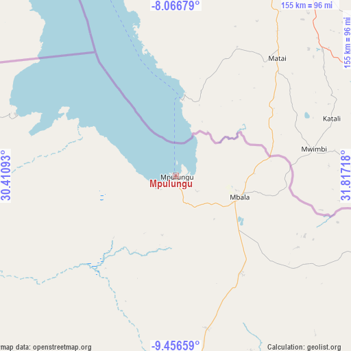
Mpulungu GPS coordinates[2]
8° 45' 44.424" South, 31° 6' 50.58" East
| Map corner | latitude | longitude |
|---|---|---|
| Upper-left | -8.06679°, | 30.41093° |
| Center: | -8.76234°, | 31.11405° |
| Lower-right: | -9.45659°, | 31.81718° |
| Map W x H: | 154.5×154.5 km | = 96×96mi |
| max Lat: | -8.46887° ⇑1.5% North |
| Mpulungu: | -8.76234° |
| min Lat: | ⇓98.5% South -17.84194° |
| min Long | Mpulungu | max Long |
| 22.67926° | 31.11405° | 33.1782° |
| W 81.8%⇐ | ⇒18.2% E |
Elevation
Elevation of Mpulungu is 800 m = 2625 ft, and this is 343.4 m = 1127 ft below average elevation for this country.
| Max E: |
1622 m = 5322 ft | 90.9% |
| Avg. | 1143.4 m = 3751 ft | |
| Mpulungu | 800 m = 2625 ft | |
Min E: |
328 m = 1076 ft | 9.1% |
See also: Zambia elevation on elevation.city.
Geographical zone
Mpulungu is located in South Torrid zone (between Equator and Tropic of Capricorn). Distance of Equator is 974.3 km =605.4 mi to North.| Distance of | km | miles | from Mpulungu |
|---|---|---|---|
| Equator | 974.3 | 605.4 | to North |
| Tropic Capricorn | 1631.6 | 1013.8 | to South |
| Antarctic Circle | 6426.9 | 3993.5 | to South |
| South Pole | 9032.8 | 5612.7 | to South |


Nearby cities:
15 places around Mpulungu: (largest is in red/bold)
• Chama
352.2 km =218.8 mi,  140°
140°
• Chinsali
224.5 km =139.5 mi,  151°
151°
• Isoka
227.9 km =141.6 mi,  133°
133°
• Kaputa
162.9 km =101.2 mi,  281°
281°
• Kasama
161.5 km =100.4 mi,  177°
177°
• Kawambwa
250.9 km =155.9 mi,  242°
242°
• Luwingu
211.5 km =131.4 mi,  217°
217°
• Mbala
29 km =18 mi,  107°
107°
• Mpika
343.6 km =213.5 mi,  173°
173°
• Mporokoso
128.1 km =79.6 mi, 237°
• Mungwi
159.4 km =99 mi, 169°
• Mwense
320.5 km =199.1 mi, 235°
• Nakonde
190.3 km =118.2 mi, 109°
• Nchelenge
269.3 km =167.3 mi,  256°
256°
• Samfya
335.9 km =208.7 mi,  210°
210°
Sources, notices
• [Note1] Compared only with cities in Zambia existing in our database
• [Src1] Map data: © OpenStreetMap contributors (CC-BY-SA)
• [Src2] Other city data from geonames.org with taken over terms of usage.
• [Src3] Geographical zone / Annual Mean Temperature by Robert A. Rohde @ Wikipedia
