Samfya geodata
Samfya (Luapula) is a populated place; located in Zambia in Africa/Lusaka (GMT+2) time zone. With population of 20,470 people, there are 24 cities with bigger population in this country. Compared to other cities in Zambia, 77.3% of cities are located further ↓South; 69.7% of cities are located further ←West and 50% of cities have lower elevation than Samfya. Note1


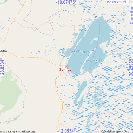
Samfya GPS coordinates[2]
11° 21' 53.676" South, 29° 33' 23.472" East
| Map corner | latitude | longitude |
|---|---|---|
| Upper-left | -10.67475°, | 28.8534° |
| Center: | -11.36491°, | 29.55652° |
| Lower-right: | -12.0534°, | 30.25965° |
| Map W x H: | 153.3×153.3 km | = 95.3×95.3mi |
| max Lat: | -8.46887° ⇑22.7% North |
| Samfya: | -11.36491° |
| min Lat: | ⇓77.3% South -17.84194° |
| min Long | Samfya | max Long |
| 22.67926° | 29.55652° | 33.1782° |
| W 69.7%⇐ | ⇒30.3% E |
Elevation
Elevation of Samfya is 1183 m = 3881 ft, and this is 39.6 m = 130 ft above average elevation for this country.
| Max E: |
1622 m = 5322 ft | 50% |
| Samfya | 1183 m 3881 ft | |
| Avg. | 1143.4 m = 3751 ft | |
Min E: |
328 m = 1076 ft | 50% |
See also: Zambia elevation on elevation.city.
Geographical zone
Samfya is located in South Torrid zone (between Equator and Tropic of Capricorn). Distance of Equator is 1263.7 km =785.2 mi to North.| Distance of | km | miles | from Samfya |
|---|---|---|---|
| Equator | 1263.7 | 785.2 | to North |
| Tropic Capricorn | 1342.3 | 834.1 | to South |
| Antarctic Circle | 6137.5 | 3813.7 | to South |
| South Pole | 8743.4 | 5432.9 | to South |


Nearby cities:
15 places around Samfya: (largest is in red/bold)
• Chambishi
215.8 km =134.1 mi,  229°
229°
• Chililabombwe
219 km =136.1 mi,  239°
239°
• Chingola
223.3 km =138.8 mi, 234°
• Kalulushi
228.5 km =142 mi,  224°
224°
• Kasama
218.8 km =136 mi,  54°
54°
• Kataba
62.7 km =39 mi,  156°
156°
• Kawambwa
182.6 km =113.5 mi,  343°
343°
• Kitwe
216.5 km =134.5 mi, 222°
• Luwingu
129.1 km =80.2 mi,  18°
18°
• Mansa
74.5 km =46.3 mi,  284°
284°
• Mpika
213 km =132.4 mi,  104°
104°
• Mufulira
194.5 km =120.9 mi, 227°
• Mwense
143.8 km =89.4 mi,  319°
319°
• Ndola
203.5 km =126.4 mi,  209°
209°
• Serenje
220.4 km =137 mi, 160°
Sources, notices
• [Note1] Compared only with cities in Zambia existing in our database
• [Src1] Map data: © OpenStreetMap contributors (CC-BY-SA)
• [Src2] Other city data from geonames.org with taken over terms of usage.
• [Src3] Geographical zone / Annual Mean Temperature by Robert A. Rohde @ Wikipedia
