Mpika geodata
Mpika (Muchinga) is a populated place; located in Zambia in Africa/Lusaka (GMT+2) time zone. With population of 28,445 people, there are 20 cities with bigger population in this country. Compared to other cities in Zambia, 74.2% of cities are located further ↓South; 89.4% of cities are located further ←West and 93.9% of cities have lower elevation than Mpika. Note1


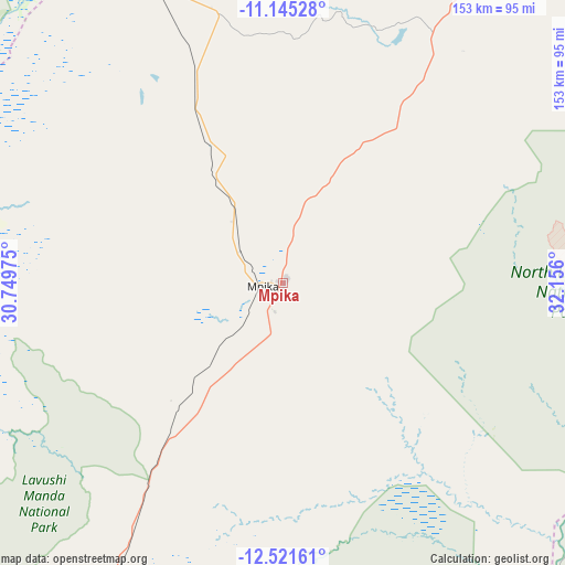
Mpika GPS coordinates[2]
11° 50' 3.516" South, 31° 27' 10.332" East
| Map corner | latitude | longitude |
|---|---|---|
| Upper-left | -11.14528°, | 30.74975° |
| Center: | -11.83431°, | 31.45287° |
| Lower-right: | -12.52161°, | 32.156° |
| Map W x H: | 153×153 km | = 95.1×95.1mi |
| max Lat: | -8.46887° ⇑25.8% North |
| Mpika: | -11.83431° |
| min Lat: | ⇓74.2% South -17.84194° |
| min Long | Mpika | max Long |
| 22.67926° | 31.45287° | 33.1782° |
| W 89.4%⇐ | ⇒10.6% E |
Elevation
Elevation of Mpika is 1428 m = 4685 ft, and this is 284.6 m = 934 ft above average elevation for this country.
| Max E: |
1622 m = 5322 ft | 6.1% |
| Mpika | 1428 m 4685 ft | |
| Avg. | 1143.4 m = 3751 ft | |
Min E: |
328 m = 1076 ft | 93.9% |
See also: Zambia elevation on elevation.city.
Geographical zone
Mpika is located in South Torrid zone (between Equator and Tropic of Capricorn). Distance of this Southern Tropic circle is 1290.1 km =801.6 mi to South.| Distance of | km | miles | from Mpika |
|---|---|---|---|
| Equator | 1315.9 | 817.7 | to North |
| Tropic Capricorn | 1290.1 | 801.6 | to South |
| Antarctic Circle | 6085.3 | 3781.2 | to South |
| South Pole | 8691.2 | 5400.5 | to South |


Nearby cities:
15 places around Mpika: (largest is in red/bold)
• Chadiza
270.4 km =168 mi,  156°
156°
• Chama
197.6 km =122.8 mi,  69°
69°
• Chinsali
159.3 km =99 mi,  25°
25°
• Chipata
238.5 km =148.2 mi,  147°
147°
• Isoka
226.4 km =140.7 mi, 34°
• Kasama
182.7 km =113.5 mi,  350°
350°
• Kataba
181.8 km =113 mi,  268°
268°
• Lundazi
194.4 km =120.8 mi,  105°
105°
• Luwingu
241.4 km =150 mi,  316°
316°
• Mansa
287.5 km =178.6 mi,  284°
284°
• Mkushi
298.8 km =185.7 mi,  228°
228°
• Mungwi
184.9 km =114.9 mi,  357°
357°
• Petauke
268 km =166.5 mi,  183°
183°
• Samfya
213 km =132.4 mi, 284°
• Serenje
204 km =126.8 mi,  220°
220°
Sources, notices
• [Note1] Compared only with cities in Zambia existing in our database
• [Src1] Map data: © OpenStreetMap contributors (CC-BY-SA)
• [Src2] Other city data from geonames.org with taken over terms of usage.
• [Src3] Geographical zone / Annual Mean Temperature by Robert A. Rohde @ Wikipedia
