Chama geodata
Chama (Muchinga) is a populated place; located in Zambia in Africa/Lusaka (GMT+2) time zone. With population of 4,061 people, there are 59 cities with bigger population in this country. Compared to other cities in Zambia, 78.8% of cities are located further ↓South; 98.5% of cities are located further ←West and 92.4% of cities have higher elevation than Chama. Note1


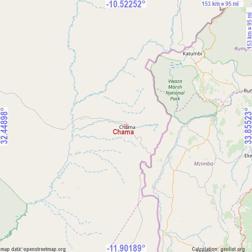
Chama GPS coordinates[2]
11° 12' 46.908" South, 33° 9' 7.56" East
| Map corner | latitude | longitude |
|---|---|---|
| Upper-left | -10.52252°, | 32.44898° |
| Center: | -11.21303°, | 33.1521° |
| Lower-right: | -11.90189°, | 33.85523° |
| Map W x H: | 153.4×153.4 km | = 95.3×95.3mi |
| max Lat: | -8.46887° ⇑21.2% North |
| Chama: | -11.21303° |
| min Lat: | ⇓78.8% South -17.84194° |
| min Long | Chama | max Long |
| 22.67926° | 33.1521° | 33.1782° |
| W 98.5%⇐ | ⇒1.5% E |
Elevation
Elevation of Chama is 765 m = 2510 ft, and this is 378.4 m = 1241 ft below average elevation for this country.
| Max E: |
1622 m = 5322 ft | 92.4% |
| Avg. | 1143.4 m = 3751 ft | |
| Chama | 765 m = 2510 ft | |
Min E: |
328 m = 1076 ft | 7.6% |
See also: Zambia elevation on elevation.city.
Geographical zone
Chama is located in South Torrid zone (between Equator and Tropic of Capricorn). Distance of Equator is 1246.8 km =774.7 mi to North.| Distance of | km | miles | from Chama |
|---|---|---|---|
| Equator | 1246.8 | 774.7 | to North |
| Tropic Capricorn | 1359.1 | 844.5 | to South |
| Antarctic Circle | 6154.4 | 3824.2 | to South |
| South Pole | 8760.3 | 5443.4 | to South |


Nearby cities:
15 places around Chama: (largest is in red/bold)
• Chadiza
326.7 km =203 mi,  193°
193°
• Chinsali
138.7 km =86.2 mi,  302°
302°
• Chipata
274.6 km =170.6 mi, 191°
• Isoka
130 km =80.8 mi,  334°
334°
• Kasama
242.4 km =150.6 mi, 297°
• Kataba
374.5 km =232.7 mi,  258°
258°
• Lundazi
120.1 km =74.6 mi,  178°
178°
• Luwingu
367.8 km =228.5 mi,  286°
286°
• Mbala
328.4 km =204.1 mi,  323°
323°
• Mpika
197.6 km =122.8 mi,  249°
249°
• Mporokoso
389.3 km =241.9 mi, 301°
• Mpulungu
352.2 km =218.8 mi, 320°
• Mungwi
226.5 km =140.7 mi, 300°
• Nakonde
212.7 km =132.2 mi,  347°
347°
• Serenje
388.4 km =241.3 mi,  234°
234°
Sources, notices
• [Note1] Compared only with cities in Zambia existing in our database
• [Src1] Map data: © OpenStreetMap contributors (CC-BY-SA)
• [Src2] Other city data from geonames.org with taken over terms of usage.
• [Src3] Geographical zone / Annual Mean Temperature by Robert A. Rohde @ Wikipedia
