Mbala geodata
Mbala (Northern) is a populated place; located in Zambia in Africa/Lusaka (GMT+2) time zone. With population of 20,570 people, there are 23 cities with bigger population in this country. Compared to other cities in Zambia, 97% of cities are located further ↓South; 86.4% of cities are located further ←West and 100% of cities have lower elevation than Mbala. Note1


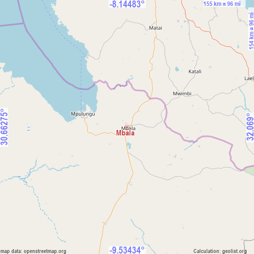
Mbala GPS coordinates[2]
8° 50' 24.864" South, 31° 21' 57.132" East
| Map corner | latitude | longitude |
|---|---|---|
| Upper-left | -8.14483°, | 30.66275° |
| Center: | -8.84024°, | 31.36587° |
| Lower-right: | -9.53434°, | 32.069° |
| Map W x H: | 154.5×154.5 km | = 96×96mi |
| max Lat: | -8.46887° ⇑3% North |
| Mbala: | -8.84024° |
| min Lat: | ⇓97% South -17.84194° |
| min Long | Mbala | max Long |
| 22.67926° | 31.36587° | 33.1782° |
| W 86.4%⇐ | ⇒13.6% E |
Elevation
Elevation of Mbala is 1622 m = 5322 ft, and this is 478.6 m = 1570 ft above average elevation for this country.
| Max E: |
1622 m = 5322 ft | 0% |
| Mbala | 1622 m 5322 ft | |
| Avg. | 1143.4 m = 3751 ft | |
Min E: |
328 m = 1076 ft | 100% |
See also: Zambia elevation on elevation.city.
Geographical zone
Mbala is located in South Torrid zone (between Equator and Tropic of Capricorn). Distance of Equator is 982.9 km =610.7 mi to North.| Distance of | km | miles | from Mbala |
|---|---|---|---|
| Equator | 982.9 | 610.7 | to North |
| Tropic Capricorn | 1623 | 1008.5 | to South |
| Antarctic Circle | 6418.2 | 3988.1 | to South |
| South Pole | 9024.1 | 5607.3 | to South |


Nearby cities:
15 places around Mbala: (largest is in red/bold)
• Chama
328.4 km =204.1 mi,  143°
143°
• Chinsali
204.8 km =127.3 mi,  157°
157°
• Isoka
202.2 km =125.6 mi, 136°
• Kaputa
191.8 km =119.2 mi,  282°
282°
• Kasama
154 km =95.7 mi,  187°
187°
• Kawambwa
272.3 km =169.2 mi,  247°
247°
• Luwingu
223.3 km =138.8 mi,  224°
224°
• Mpika
333 km =206.9 mi,  178°
178°
• Mporokoso
148.5 km =92.3 mi, 246°
• Mpulungu
29 km =18 mi,  287°
287°
• Mungwi
148.2 km =92.1 mi, 179°
• Mwense
339.1 km =210.7 mi,  239°
239°
• Nakonde
161.4 km =100.3 mi,  110°
110°
• Nchelenge
294.4 km =182.9 mi,  259°
259°
• Samfya
343.5 km =213.4 mi, 215°
Sources, notices
• [Note1] Compared only with cities in Zambia existing in our database
• [Src1] Map data: © OpenStreetMap contributors (CC-BY-SA)
• [Src2] Other city data from geonames.org with taken over terms of usage.
• [Src3] Geographical zone / Annual Mean Temperature by Robert A. Rohde @ Wikipedia
