Chadiza geodata
Chadiza (Eastern) is a populated place; located in Zambia in Africa/Lusaka (GMT+2) time zone. With population of 3,690 people, there are 60 cities with bigger population in this country. Compared to other cities in Zambia, 60.6% of cities are located further ↑North; 92.4% of cities are located further ←West and 66.7% of cities have higher elevation than Chadiza. Note1


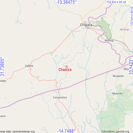
Chadiza GPS coordinates[2]
14° 4' 4.044" South, 32° 26' 21.012" East
| Map corner | latitude | longitude |
|---|---|---|
| Upper-left | -13.38475°, | 31.73605° |
| Center: | -14.06779°, | 32.43917° |
| Lower-right: | -14.7488°, | 33.1423° |
| Map W x H: | 151.7×151.7 km | = 94.3×94.3mi |
| max Lat: | -8.46887° ⇑60.6% North |
| Chadiza: | -14.06779° |
| min Lat: | ⇓39.4% South -17.84194° |
| min Long | Chadiza | max Long |
| 22.67926° | 32.43917° | 33.1782° |
| W 92.4%⇐ | ⇒7.6% E |
Elevation
Elevation of Chadiza is 1066 m = 3497 ft, and this is 77.4 m = 254 ft below average elevation for this country.
| Max E: |
1622 m = 5322 ft | 66.7% |
| Avg. | 1143.4 m = 3751 ft | |
| Chadiza | 1066 m = 3497 ft | |
Min E: |
328 m = 1076 ft | 33.3% |
See also: Zambia elevation on elevation.city.
Geographical zone
Chadiza is located in South Torrid zone (between Equator and Tropic of Capricorn). Distance of this Southern Tropic circle is 1041.7 km =647.3 mi to South.| Distance of | km | miles | from Chadiza |
|---|---|---|---|
| Equator | 1564.2 | 971.9 | to North |
| Tropic Capricorn | 1041.7 | 647.3 | to South |
| Antarctic Circle | 5837 | 3626.9 | to South |
| South Pole | 8442.9 | 5246.2 | to South |


Nearby cities:
15 places around Chadiza: (largest is in red/bold)
• Chama
326.7 km =203 mi,  13°
13°
• Chinsali
394 km =244.8 mi,  354°
354°
• Chipata
53.4 km =33.2 mi,  25°
25°
• Chongwe
427.7 km =265.8 mi,  250°
250°
• Kapiri Mposhi
406.8 km =252.8 mi,  271°
271°
• Kataba
376.5 km =233.9 mi,  310°
310°
• Luangwa
277.3 km =172.3 mi,  231°
231°
• Lundazi
212.9 km =132.3 mi,  22°
22°
• Mkushi
332.5 km =206.6 mi,  278°
278°
• Mpika
270.4 km =168 mi,  336°
336°
• Ndola
429.2 km =266.7 mi,  286°
286°
• Nyimba
183.2 km =113.8 mi, 252°
• Petauke
122.2 km =75.9 mi,  260°
260°
• Samfya
433.7 km =269.5 mi, 313°
• Serenje
255.6 km =158.8 mi, 291°
Sources, notices
• [Note1] Compared only with cities in Zambia existing in our database
• [Src1] Map data: © OpenStreetMap contributors (CC-BY-SA)
• [Src2] Other city data from geonames.org with taken over terms of usage.
• [Src3] Geographical zone / Annual Mean Temperature by Robert A. Rohde @ Wikipedia
