Lundazi geodata
Lundazi (Eastern) is a populated place; located in Zambia in Africa/Lusaka (GMT+2) time zone. With population of 11,635 people, there are 36 cities with bigger population in this country. Compared to other cities in Zambia, 68.2% of cities are located further ↓South; 100% of cities are located further ←West and 57.6% of cities have higher elevation than Lundazi. Note1


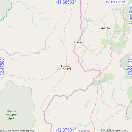
Lundazi GPS coordinates[2]
12° 17' 34.512" South, 33° 10' 41.52" East
| Map corner | latitude | longitude |
|---|---|---|
| Upper-left | -11.60503°, | 32.47508° |
| Center: | -12.29292°, | 33.1782° |
| Lower-right: | -12.97901°, | 33.88133° |
| Map W x H: | 152.8×152.8 km | = 94.9×94.9mi |
| max Lat: | -8.46887° ⇑31.8% North |
| Lundazi: | -12.29292° |
| min Lat: | ⇓68.2% South -17.84194° |
| min Long | Lundazi | max Long |
| 22.67926° | 33.1782° | 33.1782° |
| W 100%⇐ | ⇒0% E |
Elevation
Elevation of Lundazi is 1143 m = 3750 ft, and this is 0.40000000000009 m = 1 ft below average elevation for this country.
| Max E: |
1622 m = 5322 ft | 57.6% |
| Avg. | 1143.4 m = 3751 ft | |
| Lundazi | 1143 m = 3750 ft | |
Min E: |
328 m = 1076 ft | 42.4% |
See also: Zambia elevation on elevation.city.
Geographical zone
Lundazi is located in South Torrid zone (between Equator and Tropic of Capricorn). Distance of this Southern Tropic circle is 1239.1 km =769.9 mi to South.| Distance of | km | miles | from Lundazi |
|---|---|---|---|
| Equator | 1366.8 | 849.3 | to North |
| Tropic Capricorn | 1239.1 | 769.9 | to South |
| Antarctic Circle | 6034.3 | 3749.5 | to South |
| South Pole | 8640.2 | 5368.8 | to South |


Nearby cities:
15 places around Lundazi: (largest is in red/bold)
• Chadiza
212.9 km =132.3 mi,  202°
202°
• Chama
120.1 km =74.6 mi,  358°
358°
• Chinsali
228.5 km =142 mi,  328°
328°
• Chipata
159.7 km =99.2 mi, 201°
• Isoka
244.4 km =151.9 mi,  345°
345°
• Kasama
317.7 km =197.4 mi,  316°
316°
• Kataba
371.9 km =231.1 mi,  277°
277°
• Luwingu
420.3 km =261.2 mi,  302°
302°
• Mpika
194.4 km =120.8 mi,  285°
285°
• Mungwi
307.3 km =190.9 mi, 320°
• Nakonde
331.5 km =206 mi, 351°
• Nyimba
358.7 km =222.9 mi,  225°
225°
• Petauke
295.6 km =183.7 mi,  222°
222°
• Samfya
407.4 km =253.1 mi, 284°
• Serenje
335.8 km =208.7 mi,  251°
251°
Sources, notices
• [Note1] Compared only with cities in Zambia existing in our database
• [Src1] Map data: © OpenStreetMap contributors (CC-BY-SA)
• [Src2] Other city data from geonames.org with taken over terms of usage.
• [Src3] Geographical zone / Annual Mean Temperature by Robert A. Rohde @ Wikipedia
