Khadīr geodata
Khadīr (Daykundi) is a seat of a second-order administrative division; located in Afghanistan in Asia/Kabul (GMT+4.5) time zone. In our database, there are 93 cities with bigger population. Compared to other cities in Afghanistan, 67.8% of cities are located further ↑North; 72.3% of cities are located further →East and 92.9% of cities have lower elevation than Khadīr. Note1


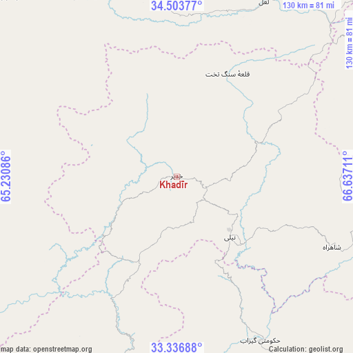
Khadīr GPS coordinates[2]
33° 55' 20.352" North, 65° 56' 2.328" East
| Map corner | latitude | longitude |
|---|---|---|
| Upper-left | 34.50377°, | 65.23086° |
| Center: | 33.92232°, | 65.93398° |
| Lower-right: | 33.33688°, | 66.63711° |
| Map W x H: | 129.7×129.7 km | = 80.6×80.6mi |
| max Lat: | 38.4435° ⇑67.8% North |
| Khadīr: | 33.92232° |
| min Lat: | ⇓32.2% South 30.15° |
| min Long | Khadīr | max Long |
| 61.06667° | 65.93398° | 72.318° |
| W 27.7%⇐ | ⇒72.3% E |
Elevation
Elevation of Khadīr is 2462 m = 8077 ft, and this is 1043.6 m = 3424 ft above average elevation for this country.
| Max E: |
3068 m = 10066 ft | 7.1% |
| Khadīr | 2462 m 8077 ft | |
| Avg. | 1418.4 m = 4654 ft | |
Min E: |
254 m = 833 ft | 92.9% |
See also: Afghanistan elevation on elevation.city.
Geographical zone
Khadīr is located in North temperate zone (between Tropic of Cancer and the Arctic Circle). Distance of this Northern Tropic circle is 1165.9 km =724.5 mi to South.| Distance of | km | miles | from Khadīr |
|---|---|---|---|
| North Pole | 6235.3 | 3874.4 | to North |
| Arctic Circle | 3629.4 | 2255.2 | to North |
| Tropic Cancer | 1165.9 | 724.5 | to South |
| Equator | 3771.8 | 2343.7 | to South |


Nearby cities:
15 places around Khadīr: (largest is in red/bold)
• Chowṉêy
67.7 km =42.1 mi,  152°
152°
• Dowlatyār
71.1 km =44.2 mi,  349°
349°
• Dū Laīnah
108.9 km =67.7 mi,  283°
283°
• Fayrōz Kōh
91.4 km =56.8 mi,  316°
316°
• Kajrān
90.6 km =56.3 mi,  208°
208°
• La‘l
71.8 km =44.6 mi,  26°
26°
• Nayak
130 km =80.8 mi,  46°
46°
• Nīlī
28.7 km =17.8 mi,  140°
140°
• Panjāb
112.8 km =70.1 mi,  62°
62°
• Pasāband
103.2 km =64.1 mi,  255°
255°
• Quchanghī
35.3 km =21.9 mi, 63°
• Sar-e Tayghān
51.7 km =32.1 mi, 207°
• Tarinkot
143.8 km =89.4 mi,  182°
182°
• Taywarah
146.8 km =91.2 mi,  252°
252°
• Uruzgān
128.2 km =79.7 mi, 149°
Sources, notices
• [Note1] Compared only with cities in Afghanistan existing in our database
• [Src1] Map data: © OpenStreetMap contributors (CC-BY-SA)
• [Src2] Other city data from geonames.org with taken over terms of usage.
• [Src3] Geographical zone / Annual Mean Temperature by Robert A. Rohde @ Wikipedia
