Dū Laīnah geodata
Dū Laīnah (Ghowr) is a seat of a second-order administrative division; located in Afghanistan in Asia/Kabul (GMT+4.5) time zone. In our database, there are 93 cities with bigger population. Compared to other cities in Afghanistan, 64% of cities are located further ↑North; 82.3% of cities are located further →East and 96.8% of cities have lower elevation than Dū Laīnah. Note1


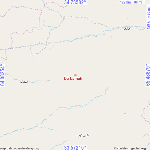
Dū Laīnah GPS coordinates[2]
34° 9' 21.564" North, 64° 47' 8.376" East
| Map corner | latitude | longitude |
|---|---|---|
| Upper-left | 34.73582°, | 64.08254° |
| Center: | 34.15599°, | 64.78566° |
| Lower-right: | 33.57215°, | 65.48879° |
| Map W x H: | 129.4×129.4 km | = 80.4×80.4mi |
| max Lat: | 38.4435° ⇑64% North |
| Dū Laīnah: | 34.15599° |
| min Lat: | ⇓36% South 30.15° |
| min Long | Dū Laīnah | max Long |
| 61.06667° | 64.78566° | 72.318° |
| W 17.7%⇐ | ⇒82.3% E |
Elevation
Elevation of Dū Laīnah is 2619 m = 8593 ft, and this is 1200.6 m = 3939 ft above average elevation for this country.
| Max E: |
3068 m = 10066 ft | 3.2% |
| Dū Laīnah | 2619 m 8593 ft | |
| Avg. | 1418.4 m = 4654 ft | |
Min E: |
254 m = 833 ft | 96.8% |
See also: Afghanistan elevation on elevation.city.
Geographical zone
Dū Laīnah is located in North temperate zone (between Tropic of Cancer and the Arctic Circle). Distance of this Northern Tropic circle is 1191.9 km =740.6 mi to South.| Distance of | km | miles | from Dū Laīnah |
|---|---|---|---|
| North Pole | 6209.3 | 3858.3 | to North |
| Arctic Circle | 3603.4 | 2239 | to North |
| Tropic Cancer | 1191.9 | 740.6 | to South |
| Equator | 3797.8 | 2359.8 | to South |


Nearby cities:
15 places around Dū Laīnah: (largest is in red/bold)
• Chisht-e Sharīf
98.5 km =61.2 mi,  282°
282°
• Dowlatyār
102.4 km =63.6 mi,  64°
64°
• Fayrōz Kōh
58.8 km =36.5 mi,  46°
46°
• Jawand
116.5 km =72.4 mi,  330°
330°
• Kajrān
123.5 km =76.7 mi,  149°
149°
• Khadīr
108.9 km =67.7 mi,  103°
103°
• Lāsh
135.9 km =84.4 mi,  359°
359°
• Nīlī
133.1 km =82.7 mi,  111°
111°
• Pasāband
52.2 km =32.4 mi,  173°
173°
• Quchanghī
137.8 km =85.6 mi,  94°
94°
• Sar-e Tayghān
109.2 km =67.9 mi,  131°
131°
• Shahrak
44.5 km =27.7 mi,  263°
263°
• Taywarah
78.2 km =48.6 mi,  205°
205°
• Tītān
99.6 km =61.9 mi,  238°
238°
• Tūlak
99.4 km =61.8 mi, 258°
Sources, notices
• [Note1] Compared only with cities in Afghanistan existing in our database
• [Src1] Map data: © OpenStreetMap contributors (CC-BY-SA)
• [Src2] Other city data from geonames.org with taken over terms of usage.
• [Src3] Geographical zone / Annual Mean Temperature by Robert A. Rohde @ Wikipedia
