Tūlak geodata
Tūlak (Ghowr) is a seat of a second-order administrative division; located in Afghanistan in Asia/Kabul (GMT+4.5) time zone. In our database, there are 93 cities with bigger population. Compared to other cities in Afghanistan, 66.9% of cities are located further ↑North; 88.7% of cities are located further →East and 86.2% of cities have lower elevation than Tūlak. Note1


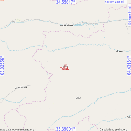
Tūlak GPS coordinates[2]
33° 58' 30.324" North, 63° 43' 43.248" East
| Map corner | latitude | longitude |
|---|---|---|
| Upper-left | 34.55617°, | 63.02556° |
| Center: | 33.97509°, | 63.72868° |
| Lower-right: | 33.39001°, | 64.43181° |
| Map W x H: | 129.7×129.7 km | = 80.6×80.6mi |
| max Lat: | 38.4435° ⇑66.9% North |
| Tūlak: | 33.97509° |
| min Lat: | ⇓33.1% South 30.15° |
| min Long | Tūlak | max Long |
| 61.06667° | 63.72868° | 72.318° |
| W 11.3%⇐ | ⇒88.7% E |
Elevation
Elevation of Tūlak is 2275 m = 7464 ft, and this is 856.6 m = 2810 ft above average elevation for this country.
| Max E: |
3068 m = 10066 ft | 13.8% |
| Tūlak | 2275 m 7464 ft | |
| Avg. | 1418.4 m = 4654 ft | |
Min E: |
254 m = 833 ft | 86.2% |
See also: Afghanistan elevation on elevation.city.
Geographical zone
Tūlak is located in North temperate zone (between Tropic of Cancer and the Arctic Circle). Distance of this Northern Tropic circle is 1171.8 km =728.1 mi to South.| Distance of | km | miles | from Tūlak |
|---|---|---|---|
| North Pole | 6229.4 | 3870.8 | to North |
| Arctic Circle | 3623.5 | 2251.5 | to North |
| Tropic Cancer | 1171.8 | 728.1 | to South |
| Equator | 3777.7 | 2347.4 | to South |


Nearby cities:
15 places around Tūlak: (largest is in red/bold)
• Adraskan
139.7 km =86.8 mi,  254°
254°
• Chisht-e Sharīf
41.4 km =25.7 mi,  1°
1°
• Dasht-e Qal‘ah
105.6 km =65.6 mi,  174°
174°
• Dū Laīnah
99.4 km =61.8 mi,  78°
78°
• Jawand
127 km =78.9 mi,  17°
17°
• Karukh
119.1 km =74 mi,  298°
298°
• Pasāband
108.6 km =67.5 mi,  106°
106°
• Qala i Naw
125.3 km =77.9 mi,  333°
333°
• Qal‘ah-ye Fārsī
49.2 km =30.6 mi,  244°
244°
• Qaryeh-ye Owbeh
67.1 km =41.7 mi,  310°
310°
• Qādis
96.6 km =60 mi,  343°
343°
• Shahrak
55.1 km =34.2 mi,  74°
74°
• Taywarah
81.5 km =50.6 mi,  128°
128°
• Tītān
34 km =21.1 mi,  158°
158°
• Āb-e Kamarī
137.8 km =85.6 mi, 333°
Sources, notices
• [Note1] Compared only with cities in Afghanistan existing in our database
• [Src1] Map data: © OpenStreetMap contributors (CC-BY-SA)
• [Src2] Other city data from geonames.org with taken over terms of usage.
• [Src3] Geographical zone / Annual Mean Temperature by Robert A. Rohde @ Wikipedia
