Chisht-e Sharīf geodata
Chisht-e Sharīf (Herat) is a seat of a second-order administrative division; located in Afghanistan in Asia/Kabul (GMT+4.5) time zone. In our database, there are 93 cities with bigger population. Compared to other cities in Afghanistan, 58.8% of cities are located further ↑North; 88.4% of cities are located further →East and 57.9% of cities have lower elevation than Chisht-e Sharīf. Note1


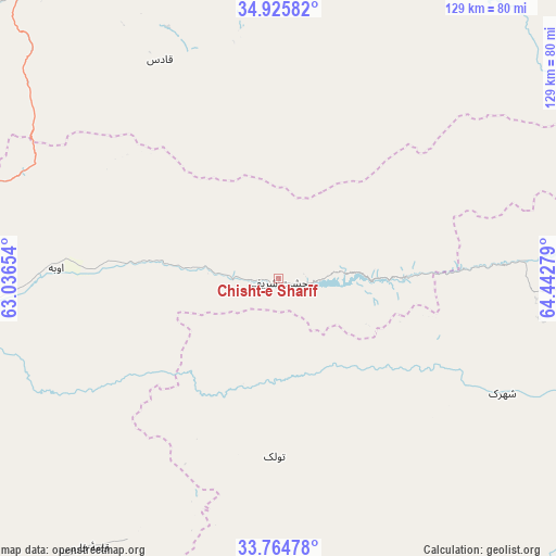
Chisht-e Sharīf GPS coordinates[2]
34° 20' 50.316" North, 63° 44' 22.776" East
| Map corner | latitude | longitude |
|---|---|---|
| Upper-left | 34.92582°, | 63.03654° |
| Center: | 34.34731°, | 63.73966° |
| Lower-right: | 33.76478°, | 64.44279° |
| Map W x H: | 129.1×129.1 km | = 80.2×80.2mi |
| max Lat: | 38.4435° ⇑58.8% North |
| Chisht-e Sharīf: | 34.34731° |
| min Lat: | ⇓41.2% South 30.15° |
| min Long | Chisht-e Sharī | max Long |
| 61.06667° | 63.73966° | 72.318° |
| W 11.6%⇐ | ⇒88.4% E |
Elevation
Elevation of Chisht-e Sharīf is 1572 m = 5157 ft, and this is 153.6 m = 504 ft above average elevation for this country.
| Max E: |
3068 m = 10066 ft | 42.1% |
| Chisht-e Sharīf | 1572 m 5157 ft | |
| Avg. | 1418.4 m = 4654 ft | |
Min E: |
254 m = 833 ft | 57.9% |
See also: Afghanistan elevation on elevation.city.
Geographical zone
Chisht-e Sharīf is located in North temperate zone (between Tropic of Cancer and the Arctic Circle). Distance of this Northern Tropic circle is 1213.1 km =753.8 mi to South.| Distance of | km | miles | from Chisht-e Sharīf |
|---|---|---|---|
| North Pole | 6188 | 3845 | to North |
| Arctic Circle | 3582.1 | 2225.8 | to North |
| Tropic Cancer | 1213.1 | 753.8 | to South |
| Equator | 3819.1 | 2373.1 | to South |


Nearby cities:
15 places around Chisht-e Sharīf: (largest is in red/bold)
• Dū Laīnah
98.5 km =61.2 mi,  102°
102°
• Jawand
88 km =54.7 mi,  25°
25°
• Karukh
106.8 km =66.4 mi,  278°
278°
• Kushk-e Kuhnah
123.7 km =76.9 mi,  298°
298°
• Pasāband
126 km =78.3 mi,  125°
125°
• Qala i Naw
90.5 km =56.2 mi,  321°
321°
• Qal‘ah-ye Fārsī
77.2 km =48 mi,  215°
215°
• Qaryeh-ye Owbeh
51.8 km =32.2 mi,  272°
272°
• Qādis
58.6 km =36.4 mi,  331°
331°
• Sang Atesh
120.6 km =74.9 mi, 326°
• Shahrak
58.4 km =36.3 mi,  117°
117°
• Taywarah
111.3 km =69.2 mi,  145°
145°
• Tītān
73.9 km =45.9 mi,  171°
171°
• Tūlak
41.4 km =25.7 mi,  181°
181°
• Āb-e Kamarī
102.7 km =63.8 mi, 323°
Sources, notices
• [Note1] Compared only with cities in Afghanistan existing in our database
• [Src1] Map data: © OpenStreetMap contributors (CC-BY-SA)
• [Src2] Other city data from geonames.org with taken over terms of usage.
• [Src3] Geographical zone / Annual Mean Temperature by Robert A. Rohde @ Wikipedia
