Jurm geodata
Jurm (Badakhshan) is a seat of a second-order administrative division; located in Afghanistan in Asia/Kabul (GMT+4.5) time zone. With population of 12,106 people, there are 60 cities with bigger population in this country. Compared to other cities in Afghanistan, 88.4% of cities are located further ↓South; 93.9% of cities are located further ←West and 57.2% of cities have lower elevation than Jurm. Note1


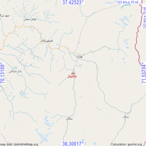
Jurm GPS coordinates[2]
36° 51' 53.172" North, 70° 50' 3.156" East
| Map corner | latitude | longitude |
|---|---|---|
| Upper-left | 37.42523°, | 70.13109° |
| Center: | 36.86477°, | 70.83421° |
| Lower-right: | 36.30017°, | 71.53734° |
| Map W x H: | 125.1×125.1 km | = 77.7×77.7mi |
| max Lat: | 38.4435° ⇑11.6% North |
| Jurm: | 36.86477° |
| min Lat: | ⇓88.4% South 30.15° |
| min Long | Jurm | max Long |
| 61.06667° | 70.83421° | 72.318° |
| W 93.9%⇐ | ⇒6.1% E |
Elevation
Elevation of Jurm is 1564 m = 5131 ft, and this is 145.6 m = 478 ft above average elevation for this country.
| Max E: |
3068 m = 10066 ft | 42.8% |
| Jurm | 1564 m 5131 ft | |
| Avg. | 1418.4 m = 4654 ft | |
Min E: |
254 m = 833 ft | 57.2% |
See also: Afghanistan elevation on elevation.city.
Geographical zone
Jurm is located in North temperate zone (between Tropic of Cancer and the Arctic Circle). Distance of this Northern Tropic circle is 1493.1 km =927.8 mi to South.| Distance of | km | miles | from Jurm |
|---|---|---|---|
| North Pole | 5908.1 | 3671.1 | to North |
| Arctic Circle | 3302.2 | 2051.9 | to North |
| Tropic Cancer | 1493.1 | 927.8 | to South |
| Equator | 4099 | 2547 | to South |


Nearby cities:
15 places around Jurm: (largest is in red/bold)
• Ashkāsham
65.5 km =40.7 mi,  107°
107°
• Bahārak
16.6 km =10.3 mi,  22°
22°
• Bāzār-e Tashkān
49.6 km =30.8 mi,  272°
272°
• Chākarān
21.5 km =13.4 mi,  76°
76°
• Darāyim
40.1 km =24.9 mi, 270°
• Fayzabad
36 km =22.4 mi,  321°
321°
• Ghurayd Gharamē
38.3 km =23.8 mi,  185°
185°
• Kalafgān
79.8 km =49.6 mi,  262°
262°
• March
81.3 km =50.5 mi,  335°
335°
• Mashhad
65.4 km =40.6 mi, 265°
• Pas Pul
70.4 km =43.7 mi, 344°
• Shahrān
15.3 km =9.5 mi,  326°
326°
• Zaybāk
58.8 km =36.5 mi,  129°
129°
• Zīrakī
84.5 km =52.5 mi, 343°
• Ḩāfiz̧ Moghul
44 km =27.3 mi,  298°
298°
Sources, notices
• [Note1] Compared only with cities in Afghanistan existing in our database
• [Src1] Map data: © OpenStreetMap contributors (CC-BY-SA)
• [Src2] Other city data from geonames.org with taken over terms of usage.
• [Src3] Geographical zone / Annual Mean Temperature by Robert A. Rohde @ Wikipedia
