Trashi Yangtse geodata
Trashi Yangtse (Trashi Yangste) is a seat of a first-order administrative division; located in Bhutan in Asia/Thimphu (GMT+6) time zone. With population of 3,025 people, there are 11 cities with bigger population in this country. Compared to other cities in Bhutan, 92.6% of cities are located further ↓South; 85.2% of cities are located further ←West and 66.7% of cities have lower elevation than Trashi Yangtse. Note1


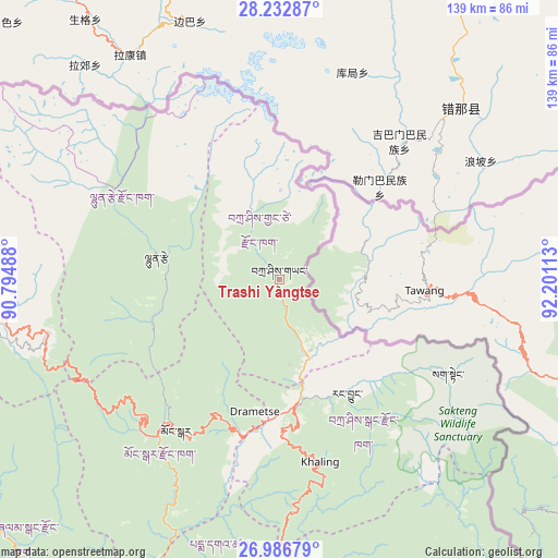
Trashi Yangtse GPS coordinates[2]
27° 36' 41.76" North, 91° 29' 52.8" East
| Map corner | latitude | longitude |
|---|---|---|
| Upper-left | 28.23287°, | 90.79488° |
| Center: | 27.6116°, | 91.498° |
| Lower-right: | 26.98679°, | 92.20113° |
| Map W x H: | 138.6×138.6 km | = 86.1×86.1mi |
| max Lat: | 27.90372° ⇑7.4% North |
| Trashi Yangtse: | 27.6116° |
| min Lat: | ⇓92.6% South 26.78333° |
| min Long | Trashi Yangtse | max Long |
| 89.09951° | 91.498° | 92.1° |
| W 85.2%⇐ | ⇒14.8% E |
Elevation
Elevation of Trashi Yangtse is 1788 m = 5866 ft, and this is 409.8 m = 1344 ft above average elevation for this country.
| Max E: |
2761 m = 9058 ft | 33.3% |
| Trashi Yangtse | 1788 m 5866 ft | |
| Avg. | 1378.2 m = 4522 ft | |
Min E: |
145 m = 476 ft | 66.7% |
See also: Bhutan elevation on elevation.city.
Geographical zone
Trashi Yangtse is located in North temperate zone (between Tropic of Cancer and the Arctic Circle). Distance of this Northern Tropic circle is 464.2 km =288.4 mi to South.| Distance of | km | miles | from Trashi Yangtse |
|---|---|---|---|
| North Pole | 6936.9 | 4310.4 | to North |
| Arctic Circle | 4331.1 | 2691.2 | to North |
| Tropic Cancer | 464.2 | 288.4 | to South |
| Equator | 3070.1 | 1907.7 | to South |


Nearby cities:
15 places around Trashi Yangtse: (largest is in red/bold)
• Bhangtar
91 km =56.5 mi,  166°
166°
• Daifam
99 km =61.5 mi,  143°
143°
• Jakar
73.8 km =45.9 mi,  264°
264°
• Lhuentse
31.6 km =19.6 mi,  281°
281°
• Mongar
45.3 km =28.1 mi,  214°
214°
• Nganglam
95.3 km =59.2 mi,  194°
194°
• Panbang
97.2 km =60.4 mi, 211°
• Pemagatshel
64.5 km =40.1 mi, 188°
• Samdrup Jongkhar
90.2 km =56 mi,  179°
179°
• Sarpang
147.3 km =91.5 mi,  235°
235°
• Shemgang
93.8 km =58.3 mi, 242°
• Trashigang
31.5 km =19.6 mi, 169°
• Trongsa
98.4 km =61.1 mi, 262°
• Tsirang
150.8 km =93.7 mi, 244°
• Wangdue Phodrang
158.2 km =98.3 mi, 264°
Sources, notices
• [Note1] Compared only with cities in Bhutan existing in our database
• [Src1] Map data: © OpenStreetMap contributors (CC-BY-SA)
• [Src2] Other city data from geonames.org with taken over terms of usage.
• [Src3] Geographical zone / Annual Mean Temperature by Robert A. Rohde @ Wikipedia
