Samdrup Jongkhar geodata
Samdrup Jongkhar is a seat of a first-order administrative division; located in Bhutan in Asia/Thimphu (GMT+6) time zone. With population of 7,507 people, there are 6 cities with bigger population in this country. Compared to other cities in Bhutan, 96.3% of cities are located further ↑North; 88.9% of cities are located further ←West and 96.3% of cities have higher elevation than Samdrup Jongkhar. Note1


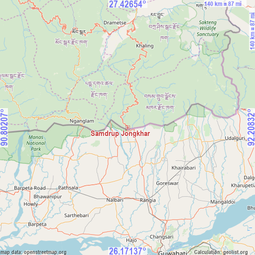
Samdrup Jongkhar GPS coordinates[2]
26° 48' 2.484" North, 91° 30' 18.684" East
| Map corner | latitude | longitude |
|---|---|---|
| Upper-left | 27.42654°, | 90.80207° |
| Center: | 26.80069°, | 91.50519° |
| Lower-right: | 26.17137°, | 92.20832° |
| Map W x H: | 139.6×139.6 km | = 86.7×86.7mi |
| max Lat: | 27.90372° ⇑96.3% North |
| Samdrup Jongkhar: | 26.80069° |
| min Lat: | ⇓3.7% South 26.78333° |
| min Long | Samdrup Jongkha | max Long |
| 89.09951° | 91.50519° | 92.1° |
| W 88.9%⇐ | ⇒11.1% E |
Elevation
Elevation of Samdrup Jongkhar is 173 m = 568 ft, and this is 1205.2 m = 3954 ft below average elevation for this country.
| Max E: |
2761 m = 9058 ft | 96.3% |
| Avg. | 1378.2 m = 4522 ft | |
| Samdrup Jongkhar | 173 m = 568 ft | |
Min E: |
145 m = 476 ft | 3.7% |
See also: Bhutan elevation on elevation.city.
Geographical zone
Samdrup Jongkhar is located in North temperate zone (between Tropic of Cancer and the Arctic Circle). Distance of this Northern Tropic circle is 374 km =232.4 mi to South.| Distance of | km | miles | from Samdrup Jongkhar |
|---|---|---|---|
| North Pole | 7027.1 | 4366.4 | to North |
| Arctic Circle | 4421.2 | 2747.2 | to North |
| Tropic Cancer | 374 | 232.4 | to South |
| Equator | 2980 | 1851.7 | to South |


Nearby cities:
15 places around Samdrup Jongkhar: (largest is in red/bold)
• Bhangtar
21.1 km =13.1 mi,  85°
85°
• Daga
164.3 km =102.1 mi,  280°
280°
• Daifam
60 km =37.3 mi,  79°
79°
• Jakar
111.7 km =69.4 mi,  318°
318°
• Lhuentse
101.5 km =63.1 mi,  341°
341°
• Mongar
58.9 km =36.6 mi,  333°
333°
• Nganglam
25.4 km =15.8 mi,  265°
265°
• Panbang
52.3 km =32.5 mi, 278°
• Pemagatshel
28.3 km =17.6 mi, 339°
• Sarpang
123 km =76.4 mi, 273°
• Shemgang
95.8 km =59.5 mi,  298°
298°
• Trashi Yangtse
90.2 km =56 mi,  359°
359°
• Trashigang
59.4 km =36.9 mi,  4°
4°
• Trongsa
125.9 km =78.2 mi,  308°
308°
• Tsirang
139.2 km =86.5 mi, 280°
Sources, notices
• [Note1] Compared only with cities in Bhutan existing in our database
• [Src1] Map data: © OpenStreetMap contributors (CC-BY-SA)
• [Src2] Other city data from geonames.org with taken over terms of usage.
• [Src3] Geographical zone / Annual Mean Temperature by Robert A. Rohde @ Wikipedia
