Bhangtar geodata
Bhangtar (Samdrup Jongkhar) is a populated place; located in Bhutan in Asia/Thimphu (GMT+6) time zone. With population of 656 people, there are 24 cities with bigger population in this country. Compared to other cities in Bhutan, 92.6% of cities are located further ↑North; 96.3% of cities are located further ←West and 88.9% of cities have higher elevation than Bhangtar. Note1


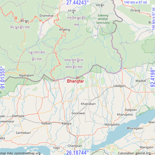
Bhangtar GPS coordinates[2]
26° 49' 0.012" North, 91° 43' 0.012" East
| Map corner | latitude | longitude |
|---|---|---|
| Upper-left | 27.44243°, | 91.01355° |
| Center: | 26.81667°, | 91.71667° |
| Lower-right: | 26.18744°, | 92.4198° |
| Map W x H: | 139.5×139.5 km | = 86.7×86.7mi |
| max Lat: | 27.90372° ⇑92.6% North |
| Bhangtar: | 26.81667° |
| min Lat: | ⇓7.4% South 26.78333° |
| min Long | Bhangtar | max Long |
| 89.09951° | 91.71667° | 92.1° |
| W 96.3%⇐ | ⇒3.7% E |
Elevation
Elevation of Bhangtar is 303 m = 994 ft, and this is 1075.2 m = 3528 ft below average elevation for this country.
| Max E: |
2761 m = 9058 ft | 88.9% |
| Avg. | 1378.2 m = 4522 ft | |
| Bhangtar | 303 m = 994 ft | |
Min E: |
145 m = 476 ft | 11.1% |
See also: Bhutan elevation on elevation.city.
Geographical zone
Bhangtar is located in North temperate zone (between Tropic of Cancer and the Arctic Circle). Distance of this Northern Tropic circle is 375.8 km =233.5 mi to South.| Distance of | km | miles | from Bhangtar |
|---|---|---|---|
| North Pole | 7025.3 | 4365.3 | to North |
| Arctic Circle | 4419.4 | 2746.1 | to North |
| Tropic Cancer | 375.8 | 233.5 | to South |
| Equator | 2981.7 | 1852.7 | to South |


Nearby cities:
15 places around Bhangtar: (largest is in red/bold)
• Daga
184.6 km =114.7 mi,  278°
278°
• Daifam
39.1 km =24.3 mi,  76°
76°
• Jakar
125.4 km =77.9 mi,  310°
310°
• Lhuentse
108.3 km =67.3 mi,  330°
330°
• Mongar
69.5 km =43.2 mi,  317°
317°
• Nganglam
46.5 km =28.9 mi,  265°
265°
• Panbang
73 km =45.4 mi, 274°
• Pemagatshel
39.6 km =24.6 mi, 308°
• Samdrup Jongkhar
21.1 km =13.1 mi, 265°
• Sarpang
143.9 km =89.4 mi, 272°
• Shemgang
113.9 km =70.8 mi,  292°
292°
• Trashi Yangtse
91 km =56.5 mi,  346°
346°
• Trashigang
59.6 km =37 mi,  344°
344°
• Trongsa
141.9 km =88.2 mi,  302°
302°
• Tsirang
159.6 km =99.2 mi, 278°
Sources, notices
• [Note1] Compared only with cities in Bhutan existing in our database
• [Src1] Map data: © OpenStreetMap contributors (CC-BY-SA)
• [Src2] Other city data from geonames.org with taken over terms of usage.
• [Src3] Geographical zone / Annual Mean Temperature by Robert A. Rohde @ Wikipedia
