Trashigang geodata
Trashigang (Tashigang) is a seat of a first-order administrative division; located in Bhutan in Asia/Thimphu (GMT+6) time zone. With population of 872 people, there are 20 cities with bigger population in this country. Compared to other cities in Bhutan, 55.6% of cities are located further ↓South; 92.6% of cities are located further ←West and 66.7% of cities have higher elevation than Trashigang. Note1


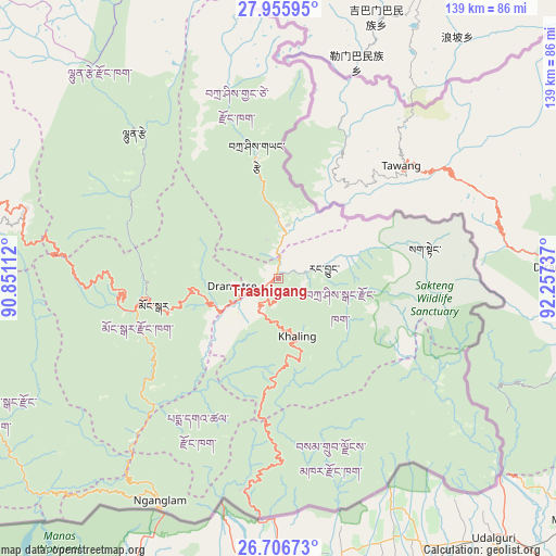
Trashigang GPS coordinates[2]
27° 19' 59.16" North, 91° 33' 15.264" East
| Map corner | latitude | longitude |
|---|---|---|
| Upper-left | 27.95595°, | 90.85112° |
| Center: | 27.3331°, | 91.55424° |
| Lower-right: | 26.70673°, | 92.25737° |
| Map W x H: | 138.9×138.9 km | = 86.3×86.3mi |
| max Lat: | 27.90372° ⇑44.4% North |
| Trashigang: | 27.3331° |
| min Lat: | ⇓55.6% South 26.78333° |
| min Long | Trashigang | max Long |
| 89.09951° | 91.55424° | 92.1° |
| W 92.6%⇐ | ⇒7.4% E |
Elevation
Elevation of Trashigang is 1174 m = 3852 ft, and this is 204.2 m = 670 ft below average elevation for this country.
| Max E: |
2761 m = 9058 ft | 66.7% |
| Avg. | 1378.2 m = 4522 ft | |
| Trashigang | 1174 m = 3852 ft | |
Min E: |
145 m = 476 ft | 33.3% |
See also: Bhutan elevation on elevation.city.
Geographical zone
Trashigang is located in North temperate zone (between Tropic of Cancer and the Arctic Circle). Distance of this Northern Tropic circle is 433.2 km =269.2 mi to South.| Distance of | km | miles | from Trashigang |
|---|---|---|---|
| North Pole | 6967.9 | 4329.7 | to North |
| Arctic Circle | 4362 | 2710.4 | to North |
| Tropic Cancer | 433.2 | 269.2 | to South |
| Equator | 3039.2 | 1888.5 | to South |


Nearby cities:
15 places around Trashigang: (largest is in red/bold)
• Bhangtar
59.6 km =37 mi,  164°
164°
• Daifam
72.4 km =45 mi,  131°
131°
• Jakar
82.7 km =51.4 mi,  286°
286°
• Lhuentse
52.1 km =32.4 mi,  315°
315°
• Mongar
31.8 km =19.8 mi,  258°
258°
• Nganglam
68.1 km =42.3 mi,  206°
206°
• Panbang
76.7 km =47.7 mi,  227°
227°
• Pemagatshel
36.1 km =22.4 mi,  204°
204°
• Samdrup Jongkhar
59.4 km =36.9 mi,  184°
184°
• Sarpang
137.6 km =85.5 mi,  247°
247°
• Shemgang
89.5 km =55.6 mi, 261°
• Trashi Yangtse
31.5 km =19.6 mi,  349°
349°
• Trongsa
105.1 km =65.3 mi,  280°
280°
• Tsirang
145.7 km =90.5 mi, 256°
• Wangdue Phodrang
164.3 km =102.1 mi, 275°
Sources, notices
• [Note1] Compared only with cities in Bhutan existing in our database
• [Src1] Map data: © OpenStreetMap contributors (CC-BY-SA)
• [Src2] Other city data from geonames.org with taken over terms of usage.
• [Src3] Geographical zone / Annual Mean Temperature by Robert A. Rohde @ Wikipedia
