Pemagatshel geodata
Pemagatshel is a seat of a first-order administrative division; located in Bhutan in Asia/Thimphu (GMT+6) time zone. With population of 13,864 people, there are 4 cities with bigger population in this country. Compared to other cities in Bhutan, 63% of cities are located further ↑North; 81.5% of cities are located further ←West and 63% of cities have higher elevation than Pemagatshel. Note1


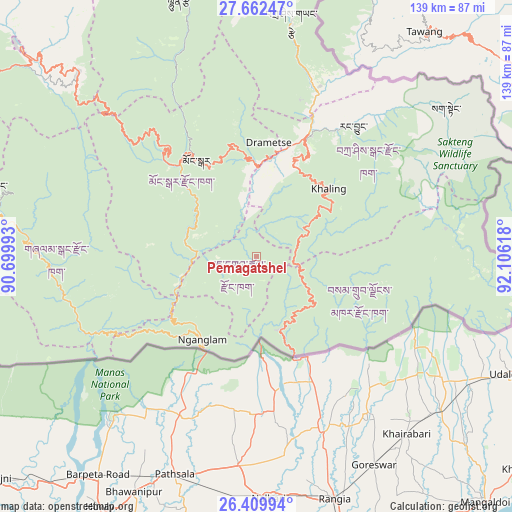
Pemagatshel GPS coordinates[2]
27° 2' 16.62" North, 91° 24' 10.98" East
| Map corner | latitude | longitude |
|---|---|---|
| Upper-left | 27.66247°, | 90.69993° |
| Center: | 27.03795°, | 91.40305° |
| Lower-right: | 26.40994°, | 92.10618° |
| Map W x H: | 139.3×139.3 km | = 86.6×86.6mi |
| max Lat: | 27.90372° ⇑63% North |
| Pemagatshel: | 27.03795° |
| min Lat: | ⇓37% South 26.78333° |
| min Long | Pemagatshel | max Long |
| 89.09951° | 91.40305° | 92.1° |
| W 81.5%⇐ | ⇒18.5% E |
Elevation
Elevation of Pemagatshel is 1207 m = 3960 ft, and this is 171.2 m = 562 ft below average elevation for this country.
| Max E: |
2761 m = 9058 ft | 63% |
| Avg. | 1378.2 m = 4522 ft | |
| Pemagatshel | 1207 m = 3960 ft | |
Min E: |
145 m = 476 ft | 37% |
See also: Bhutan elevation on elevation.city.
Geographical zone
Pemagatshel is located in North temperate zone (between Tropic of Cancer and the Arctic Circle). Distance of this Northern Tropic circle is 400.4 km =248.8 mi to South.| Distance of | km | miles | from Pemagatshel |
|---|---|---|---|
| North Pole | 7000.7 | 4350 | to North |
| Arctic Circle | 4394.8 | 2730.8 | to North |
| Tropic Cancer | 400.4 | 248.8 | to South |
| Equator | 3006.3 | 1868 | to South |


Nearby cities:
15 places around Pemagatshel: (largest is in red/bold)
• Bhangtar
39.6 km =24.6 mi,  128°
128°
• Daga
151.2 km =94 mi,  271°
271°
• Daifam
70.7 km =43.9 mi,  102°
102°
• Jakar
85.8 km =53.3 mi,  311°
311°
• Lhuentse
73.3 km =45.5 mi,  342°
342°
• Mongar
30.9 km =19.2 mi,  328°
328°
• Nganglam
32.1 km =19.9 mi,  208°
208°
• Panbang
45.8 km =28.5 mi,  245°
245°
• Samdrup Jongkhar
28.3 km =17.6 mi,  159°
159°
• Sarpang
114.2 km =71 mi,  260°
260°
• Shemgang
76.4 km =47.5 mi,  285°
285°
• Trashi Yangtse
64.5 km =40.1 mi,  8°
8°
• Trashigang
36.1 km =22.4 mi,  24°
24°
• Trongsa
102.5 km =63.7 mi,  300°
300°
• Tsirang
126.8 km =78.8 mi, 269°
Sources, notices
• [Note1] Compared only with cities in Bhutan existing in our database
• [Src1] Map data: © OpenStreetMap contributors (CC-BY-SA)
• [Src2] Other city data from geonames.org with taken over terms of usage.
• [Src3] Geographical zone / Annual Mean Temperature by Robert A. Rohde @ Wikipedia
