Nganglam geodata
Nganglam (Samdrup Jongkhar) is a populated place; located in Bhutan in Asia/Thimphu (GMT+6) time zone. With population of 707 people, there are 22 cities with bigger population in this country. Compared to other cities in Bhutan, 100% of cities are located further ↑North; 77.8% of cities are located further ←West and 100% of cities have higher elevation than Nganglam. Note1


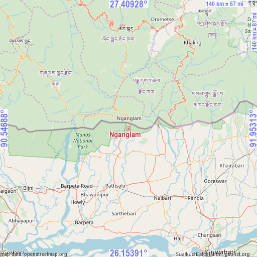
Nganglam GPS coordinates[2]
26° 46' 59.988" North, 91° 15' 0" East
| Map corner | latitude | longitude |
|---|---|---|
| Upper-left | 27.40928°, | 90.54688° |
| Center: | 26.78333°, | 91.25° |
| Lower-right: | 26.15391°, | 91.95313° |
| Map W x H: | 139.6×139.6 km | = 86.7×86.7mi |
| max Lat: | 27.90372° ⇑100% North |
| Nganglam: | 26.78333° |
| min Lat: | ⇓0% South 26.78333° |
| min Long | Nganglam | max Long |
| 89.09951° | 91.25° | 92.1° |
| W 77.8%⇐ | ⇒22.2% E |
Elevation
Elevation of Nganglam is 145 m = 476 ft, and this is 1233.2 m = 4046 ft below average elevation for this country.
| Max E: |
2761 m = 9058 ft | 100% |
| Avg. | 1378.2 m = 4522 ft | |
| Nganglam | 145 m = 476 ft | |
Min E: |
145 m = 476 ft | 0% |
See also: Bhutan elevation on elevation.city.
Geographical zone
Nganglam is located in North temperate zone (between Tropic of Cancer and the Arctic Circle). Distance of this Northern Tropic circle is 372.1 km =231.2 mi to South.| Distance of | km | miles | from Nganglam |
|---|---|---|---|
| North Pole | 7029 | 4367.6 | to North |
| Arctic Circle | 4423.1 | 2748.4 | to North |
| Tropic Cancer | 372.1 | 231.2 | to South |
| Equator | 2978 | 1850.4 | to South |


Nearby cities:
15 places around Nganglam: (largest is in red/bold)
• Bhangtar
46.5 km =28.9 mi,  85°
85°
• Daga
139.9 km =86.9 mi,  283°
283°
• Daifam
85.3 km =53 mi,  81°
81°
• Jakar
98.4 km =61.1 mi,  329°
329°
• Lhuentse
98.6 km =61.3 mi,  356°
356°
• Mongar
54.6 km =33.9 mi, 358°
• Panbang
28 km =17.4 mi,  289°
289°
• Pemagatshel
32.1 km =19.9 mi,  28°
28°
• Samdrup Jongkhar
25.4 km =15.8 mi, 85°
• Sarpang
97.9 km =60.8 mi, 275°
• Shemgang
75.9 km =47.2 mi,  309°
309°
• Trashi Yangtse
95.3 km =59.2 mi,  14°
14°
• Trashigang
68.1 km =42.3 mi, 26°
• Trongsa
108.6 km =67.5 mi,  317°
317°
• Tsirang
114.9 km =71.4 mi, 283°
Sources, notices
• [Note1] Compared only with cities in Bhutan existing in our database
• [Src1] Map data: © OpenStreetMap contributors (CC-BY-SA)
• [Src2] Other city data from geonames.org with taken over terms of usage.
• [Src3] Geographical zone / Annual Mean Temperature by Robert A. Rohde @ Wikipedia
