Semera geodata
Semera (Āfar) is a seat of a first-order administrative division; located in Ethiopia in Africa/Addis_Ababa (GMT+3) time zone. With population of 833 people, there are 107 cities with bigger population in this country. Compared to other cities in Ethiopia, 86.9% of cities are located further ↓South; 93.5% of cities are located further ←West and 97.2% of cities have higher elevation than Semera. Note1


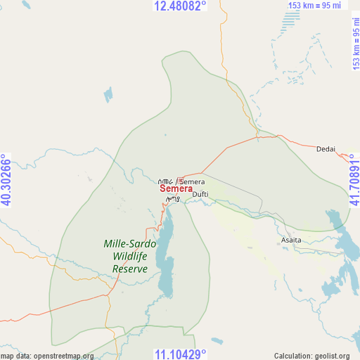
Semera GPS coordinates[2]
11° 47' 36.312" North, 41° 0' 20.808" East
| Map corner | latitude | longitude |
|---|---|---|
| Upper-left | 12.48082°, | 40.30266° |
| Center: | 11.79342°, | 41.00578° |
| Lower-right: | 11.10429°, | 41.70891° |
| Map W x H: | 153.1×153.1 km | = 95.1×95.1mi |
| max Lat: | 14.277° ⇑13.1% North |
| Semera: | 11.79342° |
| min Lat: | ⇓86.9% South 4.05° |
| min Long | Semera | max Long |
| 34.53333° | 41.00578° | 42.8° |
| W 93.5%⇐ | ⇒6.5% E |
Elevation
Elevation of Semera is 433 m = 1421 ft, and this is 1462.6 m = 4799 ft below average elevation for this country.
| Max E: |
2854 m = 9364 ft | 97.2% |
| Avg. | 1895.6 m = 6219 ft | |
| Semera | 433 m = 1421 ft | |
Min E: |
367 m = 1204 ft | 2.8% |
See also: Ethiopia elevation on elevation.city.
Geographical zone
Semera is located in North Torrid zone (between Equator and Tropic of Cancer). Distance of this Northern Tropic circle is 1294.6 km =804.4 mi to North.| Distance of | km | miles | from Semera |
|---|---|---|---|
| North Pole | 8695.8 | 5403.3 | to North |
| Arctic Circle | 6089.9 | 3784.1 | to North |
| Tropic Cancer | 1294.6 | 804.4 | to North |
| Equator | 1311.3 | 814.8 | to South |


Nearby cities:
15 places around Semera: (largest is in red/bold)
• Abomsa
230.1 km =143 mi,  209°
209°
• Asaita
53.4 km =33.2 mi,  117°
117°
• Batī
126.9 km =78.9 mi,  238°
238°
• Debre Sīna
255.6 km =158.8 mi, 212°
• Desē
166.6 km =103.5 mi, 243°
• Dubti
10.7 km =6.6 mi,  129°
129°
• Gewanē
185.1 km =115 mi,  192°
192°
• Kemisē
172.3 km =107.1 mi,  225°
225°
• Kombolcha
158.7 km =98.6 mi, 240°
• Korem
179.6 km =111.6 mi,  296°
296°
• Lalībela
214.7 km =133.4 mi,  277°
277°
• Maych’ew
193.6 km =120.3 mi, 304°
• Mek'ele
251.9 km =156.5 mi,  318°
318°
• Robīt
151.4 km =94.1 mi, 279°
• Were Īlu
217.2 km =135 mi, 231°
Sources, notices
• [Note1] Compared only with cities in Ethiopia existing in our database
• [Src1] Map data: © OpenStreetMap contributors (CC-BY-SA)
• [Src2] Other city data from geonames.org with taken over terms of usage.
• [Src3] Geographical zone / Annual Mean Temperature by Robert A. Rohde @ Wikipedia
