Asaita geodata
Asaita (Āfar) is a populated place; located in Ethiopia in Africa/Addis_Ababa (GMT+3) time zone. With population of 20,342 people, there are 64 cities with bigger population in this country. Compared to other cities in Ethiopia, 84.1% of cities are located further ↓South; 96.3% of cities are located further ←West and 99.1% of cities have higher elevation than Asaita. Note1


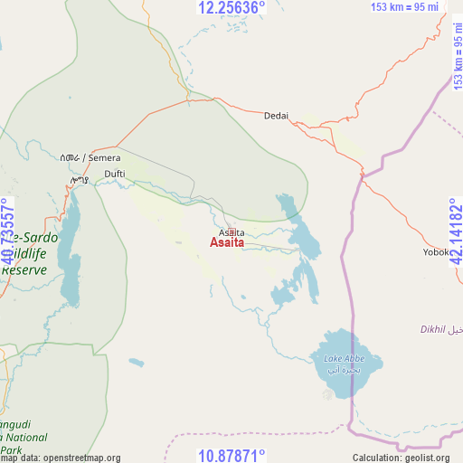
Asaita GPS coordinates[2]
11° 34' 6.168" North, 41° 26' 19.284" East
| Map corner | latitude | longitude |
|---|---|---|
| Upper-left | 12.25636°, | 40.73557° |
| Center: | 11.56838°, | 41.43869° |
| Lower-right: | 10.87871°, | 42.14182° |
| Map W x H: | 153.2×153.2 km | = 95.2×95.2mi |
| max Lat: | 14.277° ⇑15.9% North |
| Asaita: | 11.56838° |
| min Lat: | ⇓84.1% South 4.05° |
| min Long | Asaita | max Long |
| 34.53333° | 41.43869° | 42.8° |
| W 96.3%⇐ | ⇒3.7% E |
Elevation
Elevation of Asaita is 371 m = 1217 ft, and this is 1524.6 m = 5002 ft below average elevation for this country.
| Max E: |
2854 m = 9364 ft | 99.1% |
| Avg. | 1895.6 m = 6219 ft | |
| Asaita | 371 m = 1217 ft | |
Min E: |
367 m = 1204 ft | 0.9% |
See also: Ethiopia elevation on elevation.city.
Geographical zone
Asaita is located in North Torrid zone (between Equator and Tropic of Cancer). Distance of Equator is 1286.3 km =799.3 mi to South.| Distance of | km | miles | from Asaita |
|---|---|---|---|
| North Pole | 8720.8 | 5418.9 | to North |
| Arctic Circle | 6114.9 | 3799.6 | to North |
| Tropic Cancer | 1319.6 | 820 | to North |
| Equator | 1286.3 | 799.3 | to South |


Nearby cities:
15 places around Asaita: (largest is in red/bold)
• Abomsa
237.3 km =147.5 mi,  222°
222°
• Batī
160.6 km =99.8 mi,  254°
254°
• Deder
250.9 km =155.9 mi,  179°
179°
• Desē
202.7 km =126 mi,  256°
256°
• Dire Dawa
224.5 km =139.5 mi,  167°
167°
• Dubti
42.9 km =26.7 mi,  295°
295°
• Gewanē
178.2 km =110.7 mi,  209°
209°
• Harar
261.5 km =162.5 mi,  163°
163°
• Kemisē
195.6 km =121.5 mi,  241°
241°
• Kombolcha
192.6 km =119.7 mi, 253°
• Korem
233 km =144.8 mi, 296°
• Maych’ew
246.7 km =153.3 mi, 303°
• Robīt
202.7 km =126 mi,  284°
284°
• Semera
53.4 km =33.2 mi, 297°
• Were Īlu
244 km =151.6 mi, 243°
Sources, notices
• [Note1] Compared only with cities in Ethiopia existing in our database
• [Src1] Map data: © OpenStreetMap contributors (CC-BY-SA)
• [Src2] Other city data from geonames.org with taken over terms of usage.
• [Src3] Geographical zone / Annual Mean Temperature by Robert A. Rohde @ Wikipedia
