Hīrna geodata
Hīrna (Oromiya) is a populated place; located in Ethiopia in Africa/Addis_Ababa (GMT+3) time zone. With population of 12,295 people, there are 83 cities with bigger population in this country. Compared to other cities in Ethiopia, 58.9% of cities are located further ↓South; 95.3% of cities are located further ←West and 60.7% of cities have higher elevation than Hīrna. Note1


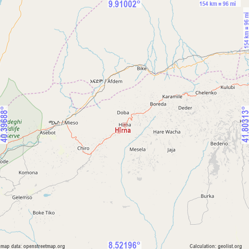
Hīrna GPS coordinates[2]
9° 13' 0.012" North, 41° 6' 0" East
| Map corner | latitude | longitude |
|---|---|---|
| Upper-left | 9.91002°, | 40.39688° |
| Center: | 9.21667°, | 41.1° |
| Lower-right: | 8.52196°, | 41.80313° |
| Map W x H: | 154.3×154.3 km | = 95.9×95.9mi |
| max Lat: | 14.277° ⇑41.1% North |
| Hīrna: | 9.21667° |
| min Lat: | ⇓58.9% South 4.05° |
| min Long | Hīrna | max Long |
| 34.53333° | 41.1° | 42.8° |
| W 95.3%⇐ | ⇒4.7% E |
Elevation
Elevation of Hīrna is 1789 m = 5869 ft, and this is 106.6 m = 350 ft below average elevation for this country.
| Max E: |
2854 m = 9364 ft | 60.7% |
| Avg. | 1895.6 m = 6219 ft | |
| Hīrna | 1789 m = 5869 ft | |
Min E: |
367 m = 1204 ft | 39.3% |
See also: Ethiopia elevation on elevation.city.
Geographical zone
Hīrna is located in North Torrid zone (between Equator and Tropic of Cancer). Distance of Equator is 1024.8 km =636.8 mi to South.| Distance of | km | miles | from Hīrna |
|---|---|---|---|
| North Pole | 8982.3 | 5581.3 | to North |
| Arctic Circle | 6376.4 | 3962.1 | to North |
| Tropic Cancer | 1581.1 | 982.4 | to North |
| Equator | 1024.8 | 636.8 | to South |


Nearby cities:
15 places around Hīrna: (largest is in red/bold)
• Abomsa
149.2 km =92.7 mi,  304°
304°
• Bedēsa
49.5 km =30.8 mi,  224°
224°
• Debre Birhan
179.5 km =111.5 mi,  286°
286°
• Debre Sīna
162.8 km =101.2 mi, 295°
• Deder
39.1 km =24.3 mi,  74°
74°
• Dire Dawa
93.9 km =58.3 mi,  63°
63°
• Gelemso
78 km =48.5 mi,  235°
235°
• Gewanē
116.7 km =72.5 mi,  334°
334°
• Harar
112.3 km =69.8 mi,  84°
84°
• Jijiga
187.1 km =116.3 mi,  85°
85°
• Kemisē
214.4 km =133.2 mi,  321°
321°
• Metahāra
134.6 km =83.6 mi,  254°
254°
• Sirre
203.9 km =126.7 mi, 240°
• Āsbe Teferī
29.4 km =18.3 mi, 240°
• Āwash
105.7 km =65.7 mi,  255°
255°
Sources, notices
• [Note1] Compared only with cities in Ethiopia existing in our database
• [Src1] Map data: © OpenStreetMap contributors (CC-BY-SA)
• [Src2] Other city data from geonames.org with taken over terms of usage.
• [Src3] Geographical zone / Annual Mean Temperature by Robert A. Rohde @ Wikipedia
