Deder geodata
Deder (Oromiya) is a populated place; located in Ethiopia in Africa/Addis_Ababa (GMT+3) time zone. With population of 8,884 people, there are 98 cities with bigger population in this country. Compared to other cities in Ethiopia, 59.8% of cities are located further ↓South; 97.2% of cities are located further ←West and 74.8% of cities have lower elevation than Deder. Note1


Deder GPS coordinates[2]
9° 18' 42.048" North, 41° 26' 34.836" East
| Map corner | latitude | longitude |
|---|---|---|
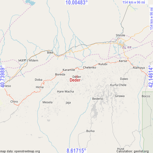
| Upper-left | 10.00483°, | 40.73989° |
| Center: | 9.31168°, | 41.44301° |
| Lower-right: | 8.61715°, | 42.14614° |
| Map W x H: | 154.3×154.3 km | = 95.9×95.9mi |
| max Lat: | 14.277° ⇑40.2% North |
| Deder: | 9.31168° |
| min Lat: | ⇓59.8% South 4.05° |
| min Long | Deder | max Long |
| 34.53333° | 41.44301° | 42.8° |
| W 97.2%⇐ | ⇒2.8% E |
Elevation
Elevation of Deder is 2330 m = 7644 ft, and this is 434.4 m = 1425 ft above average elevation for this country.
| Max E: |
2854 m = 9364 ft | 25.2% |
| Deder | 2330 m 7644 ft | |
| Avg. | 1895.6 m = 6219 ft | |
Min E: |
367 m = 1204 ft | 74.8% |
See also: Ethiopia elevation on elevation.city.
Geographical zone
Deder is located in North Torrid zone (between Equator and Tropic of Cancer). Distance of Equator is 1035.4 km =643.4 mi to South.| Distance of | km | miles | from Deder |
|---|---|---|---|
| North Pole | 8971.7 | 5574.8 | to North |
| Arctic Circle | 6365.8 | 3955.5 | to North |
| Tropic Cancer | 1570.6 | 975.9 | to North |
| Equator | 1035.4 | 643.4 | to South |


Nearby cities:
15 places around Deder: (largest is in red/bold)
• Abomsa
176.6 km =109.7 mi,  295°
295°
• Bedēsa
85.7 km =53.3 mi,  237°
237°
• Debre Birhan
213.5 km =132.7 mi,  281°
281°
• Debre Sīna
193.9 km =120.5 mi,  287°
287°
• Dire Dawa
56 km =34.8 mi,  56°
56°
• Gelemso
115.6 km =71.8 mi, 241°
• Gewanē
129 km =80.2 mi,  317°
317°
• Harar
74.1 km =46 mi,  89°
89°
• Hīrna
39.1 km =24.3 mi,  254°
254°
• Jijiga
148.9 km =92.5 mi, 88°
• Kemisē
232.5 km =144.5 mi,  312°
312°
• Metahāra
173.7 km =107.9 mi, 254°
• Sirre
242.1 km =150.4 mi, 242°
• Āsbe Teferī
68 km =42.3 mi, 248°
• Āwash
144.8 km =90 mi,  255°
255°
Sources, notices
• [Note1] Compared only with cities in Ethiopia existing in our database
• [Src1] Map data: © OpenStreetMap contributors (CC-BY-SA)
• [Src2] Other city data from geonames.org with taken over terms of usage.
• [Src3] Geographical zone / Annual Mean Temperature by Robert A. Rohde @ Wikipedia
