Harar geodata
Harar (Harari) is a seat of a first-order administrative division; located in Ethiopia in Africa/Addis_Ababa (GMT+3) time zone. With population of 90,218 people, there are 11 cities with bigger population in this country. Compared to other cities in Ethiopia, 60.7% of cities are located further ↓South; 99.1% of cities are located further ←West and 52.3% of cities have lower elevation than Harar. Note1


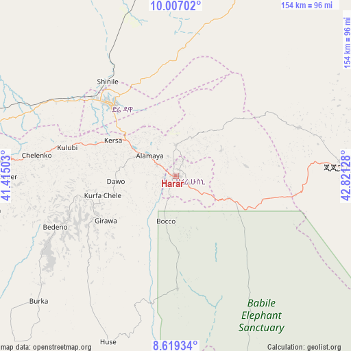
Harar GPS coordinates[2]
9° 18' 49.932" North, 42° 7' 5.34" East
| Map corner | latitude | longitude |
|---|---|---|
| Upper-left | 10.00702°, | 41.41503° |
| Center: | 9.31387°, | 42.11815° |
| Lower-right: | 8.61934°, | 42.82128° |
| Map W x H: | 154.3×154.3 km | = 95.9×95.9mi |
| max Lat: | 14.277° ⇑39.3% North |
| Harar: | 9.31387° |
| min Lat: | ⇓60.7% South 4.05° |
| min Long | Harar | max Long |
| 34.53333° | 42.11815° | 42.8° |
| W 99.1%⇐ | ⇒0.90000000000001% E |
Elevation
Elevation of Harar is 1917 m = 6289 ft, and this is 21.4 m = 70 ft above average elevation for this country.
| Max E: |
2854 m = 9364 ft | 47.7% |
| Harar | 1917 m 6289 ft | |
| Avg. | 1895.6 m = 6219 ft | |
Min E: |
367 m = 1204 ft | 52.3% |
See also: Harar elevation on elevation.city.
Geographical zone
Harar is located in North Torrid zone (between Equator and Tropic of Cancer). Distance of Equator is 1035.6 km =643.5 mi to South.| Distance of | km | miles | from Harar |
|---|---|---|---|
| North Pole | 8971.5 | 5574.6 | to North |
| Arctic Circle | 6365.6 | 3955.4 | to North |
| Tropic Cancer | 1570.3 | 975.7 | to North |
| Equator | 1035.6 | 643.5 | to South |


Nearby cities:
15 places around Harar: (largest is in red/bold)
• Abomsa
245.6 km =152.6 mi,  287°
287°
• Asaita
261.5 km =162.5 mi,  343°
343°
• Bedēsa
153.6 km =95.4 mi,  252°
252°
• Debre Birhan
286.4 km =178 mi,  278°
278°
• Debre Sīna
265.2 km =164.8 mi, 282°
• Deder
74.1 km =46 mi,  269°
269°
• Dire Dawa
41.6 km =25.8 mi,  318°
318°
• Gelemso
184.3 km =114.5 mi, 252°
• Gewanē
187 km =116.2 mi,  300°
300°
• Ginir
287.1 km =178.4 mi,  212°
212°
• Hīrna
112.3 km =69.8 mi,  264°
264°
• Jijiga
74.9 km =46.5 mi,  86°
86°
• Metahāra
246 km =152.9 mi, 259°
• Āsbe Teferī
139.6 km =86.7 mi, 259°
• Āwash
217.4 km =135.1 mi, 260°
Sources, notices
• [Note1] Compared only with cities in Ethiopia existing in our database
• [Src1] Map data: © OpenStreetMap contributors (CC-BY-SA)
• [Src2] Other city data from geonames.org with taken over terms of usage.
• [Src3] Geographical zone / Annual Mean Temperature by Robert A. Rohde @ Wikipedia
