Dire Dawa geodata
Dire Dawa is a seat of a first-order administrative division; located in Ethiopia in Africa/Addis_Ababa (GMT+3) time zone. With population of 252,279 people, there is 1 city with bigger population in this country. Compared to other cities in Ethiopia, 64.5% of cities are located further ↓South; 98.1% of cities are located further ←West and 89.7% of cities have higher elevation than Dire Dawa. Note1


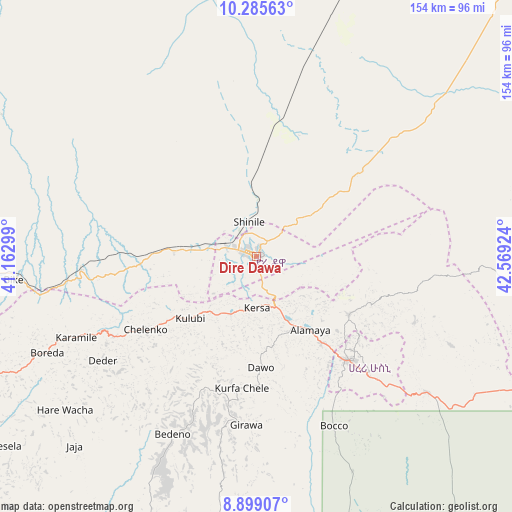
Dire Dawa GPS coordinates[2]
9° 35' 35.016" North, 41° 51' 57.996" East
| Map corner | latitude | longitude |
|---|---|---|
| Upper-left | 10.28563°, | 41.16299° |
| Center: | 9.59306°, | 41.86611° |
| Lower-right: | 8.89907°, | 42.56924° |
| Map W x H: | 154.2×154.2 km | = 95.8×95.8mi |
| max Lat: | 14.277° ⇑35.5% North |
| Dire Dawa: | 9.59306° |
| min Lat: | ⇓64.5% South 4.05° |
| min Long | Dire Dawa | max Long |
| 34.53333° | 41.86611° | 42.8° |
| W 98.1%⇐ | ⇒1.9% E |
Elevation
Elevation of Dire Dawa is 1204 m = 3950 ft, and this is 691.6 m = 2269 ft below average elevation for this country.
| Max E: |
2854 m = 9364 ft | 89.7% |
| Avg. | 1895.6 m = 6219 ft | |
| Dire Dawa | 1204 m = 3950 ft | |
Min E: |
367 m = 1204 ft | 10.3% |
See also: Dire Dawa elevation on elevation.city.
Geographical zone
Dire Dawa is located in North Torrid zone (between Equator and Tropic of Cancer). Distance of Equator is 1066.6 km =662.8 mi to South.| Distance of | km | miles | from Dire Dawa |
|---|---|---|---|
| North Pole | 8940.4 | 5555.3 | to North |
| Arctic Circle | 6334.5 | 3936.1 | to North |
| Tropic Cancer | 1539.3 | 956.5 | to North |
| Equator | 1066.6 | 662.8 | to South |


Nearby cities:
15 places around Dire Dawa: (largest is in red/bold)
• Abomsa
210.8 km =131 mi,  281°
281°
• Asaita
224.5 km =139.5 mi,  347°
347°
• Bedēsa
141.6 km =88 mi,  237°
237°
• Debre Sīna
232.5 km =144.5 mi, 276°
• Deder
56 km =34.8 mi, 236°
• Dubti
252.9 km =157.1 mi,  340°
340°
• Gelemso
171.4 km =106.5 mi, 239°
• Gewanē
148 km =92 mi,  295°
295°
• Harar
41.6 km =25.8 mi,  138°
138°
• Hīrna
93.9 km =58.3 mi, 243°
• Jijiga
105.9 km =65.8 mi,  104°
104°
• Kemisē
251.7 km =156.4 mi, 299°
• Metahāra
227.4 km =141.3 mi,  250°
250°
• Āsbe Teferī
123.3 km =76.6 mi, 242°
• Āwash
198.4 km =123.3 mi, 250°
Sources, notices
• [Note1] Compared only with cities in Ethiopia existing in our database
• [Src1] Map data: © OpenStreetMap contributors (CC-BY-SA)
• [Src2] Other city data from geonames.org with taken over terms of usage.
• [Src3] Geographical zone / Annual Mean Temperature by Robert A. Rohde @ Wikipedia
