Turgen geodata
Turgen (Almaty Oblysy) is a populated place; located in Kazakhstan in Asia/Almaty (GMT+5) time zone. With population of 13,000 people, there are 95 cities with bigger population in this country. Compared to other cities in Kazakhstan, 85.2% of cities are located further ↑North; 82.6% of cities are located further ←West and 97% of cities have lower elevation than Turgen. Note1


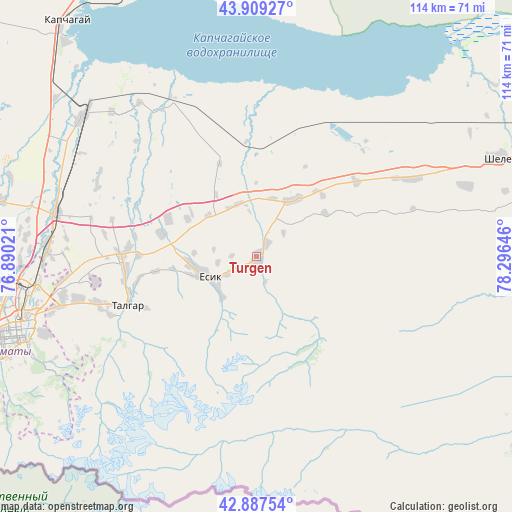
Turgen GPS coordinates[2]
43° 24' 2.016" North, 77° 35' 35.988" East
| Map corner | latitude | longitude |
|---|---|---|
| Upper-left | 43.90927°, | 76.89021° |
| Center: | 43.40056°, | 77.59333° |
| Lower-right: | 42.88754°, | 78.29646° |
| Map W x H: | 113.6×113.6 km | = 70.6×70.6mi |
| max Lat: | 54.90596° ⇑85.2% North |
| Turgen: | 43.40056° |
| min Lat: | ⇓14.8% South 40.66338° |
| min Long | Turgen | max Long |
| 46.83361° | 77.59333° | 84.87144° |
| W 82.6%⇐ | ⇒17.4% E |
Elevation
Elevation of Turgen is 971 m = 3186 ft, and this is 614.5 m = 2016 ft above average elevation for this country.
| Max E: |
1847 m = 6060 ft | 3% |
| Turgen | 971 m 3186 ft | |
| Avg. | 356.5 m = 1170 ft | |
Min E: |
-26 m = -85 ft | 97% |
See also: Kazakhstan elevation on elevation.city.
Geographical zone
Turgen is located in North temperate zone (between Tropic of Cancer and the Arctic Circle). Distance of this Northern Tropic circle is 2219.8 km =1379.3 mi to South.| Distance of | km | miles | from Turgen |
|---|---|---|---|
| North Pole | 5181.4 | 3219.6 | to North |
| Arctic Circle | 2575.5 | 1600.3 | to North |
| Tropic Cancer | 2219.8 | 1379.3 | to South |
| Equator | 4825.7 | 2998.6 | to South |


Nearby cities:
15 places around Turgen: (largest is in red/bold)
• Almaty
56.1 km =34.9 mi,  253°
253°
• Bakanas
188.8 km =117.3 mi,  326°
326°
• Balpyk Bī
174.6 km =108.5 mi,  16°
16°
• Burunday
59.9 km =37.2 mi,  265°
265°
• Chemolgan
78.3 km =48.7 mi, 268°
• Esik
12.5 km =7.8 mi, 246°
• Kapshagay
67.1 km =41.7 mi,  320°
320°
• Kegen
138.4 km =86 mi,  107°
107°
• Otegen Batyra
46.3 km =28.8 mi, 272°
• Pervomayka
52.9 km =32.9 mi, 266°
• Saryozek
111.1 km =69 mi, 15°
• Taldykorgan
190 km =118.1 mi, 19°
• Talghar
30.5 km =19 mi, 249°
• Tekeli
187.4 km =116.4 mi,  31°
31°
• Ush-Tyube
208.1 km =129.3 mi,  8°
8°
Sources, notices
• [Note1] Compared only with cities in Kazakhstan existing in our database
• [Src1] Map data: © OpenStreetMap contributors (CC-BY-SA)
• [Src2] Other city data from geonames.org with taken over terms of usage.
• [Src3] Geographical zone / Annual Mean Temperature by Robert A. Rohde @ Wikipedia
