Talghar geodata
Talghar (Almaty Oblysy) is a populated place; located in Kazakhstan in Asia/Almaty (GMT+5) time zone. With population of 42,194 people, there are 35 cities with bigger population in this country. Compared to other cities in Kazakhstan, 87.4% of cities are located further ↑North; 81.1% of cities are located further ←West and 97.8% of cities have lower elevation than Talghar. Note1


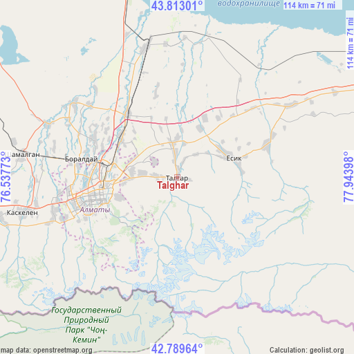
Talghar GPS coordinates[2]
43° 18' 12.528" North, 77° 14' 27.06" East
| Map corner | latitude | longitude |
|---|---|---|
| Upper-left | 43.81301°, | 76.53773° |
| Center: | 43.30348°, | 77.24085° |
| Lower-right: | 42.78964°, | 77.94398° |
| Map W x H: | 113.8×113.8 km | = 70.7×70.7mi |
| max Lat: | 54.90596° ⇑87.4% North |
| Talghar: | 43.30348° |
| min Lat: | ⇓12.6% South 40.66338° |
| min Long | Talghar | max Long |
| 46.83361° | 77.24085° | 84.87144° |
| W 81.1%⇐ | ⇒18.9% E |
Elevation
Elevation of Talghar is 974 m = 3196 ft, and this is 617.5 m = 2026 ft above average elevation for this country.
| Max E: |
1847 m = 6060 ft | 2.2% |
| Talghar | 974 m 3196 ft | |
| Avg. | 356.5 m = 1170 ft | |
Min E: |
-26 m = -85 ft | 97.8% |
See also: Talghar elevation on elevation.city.
Geographical zone
Talghar is located in North temperate zone (between Tropic of Cancer and the Arctic Circle). Distance of this Northern Tropic circle is 2209 km =1372.6 mi to South.| Distance of | km | miles | from Talghar |
|---|---|---|---|
| North Pole | 5192.2 | 3226.3 | to North |
| Arctic Circle | 2586.3 | 1607.1 | to North |
| Tropic Cancer | 2209 | 1372.6 | to South |
| Equator | 4814.9 | 2991.8 | to South |


Nearby cities:
15 places around Talghar: (largest is in red/bold)
• Almaty
25.8 km =16 mi,  258°
258°
• Bakanas
184.4 km =114.6 mi,  335°
335°
• Balpyk Bī
194.6 km =120.9 mi,  23°
23°
• Burunday
31.8 km =19.8 mi,  280°
280°
• Chemolgan
50.5 km =31.4 mi, 279°
• Esik
18.1 km =11.2 mi,  71°
71°
• Georgiyevka
207.1 km =128.7 mi, 261°
• Kapshagay
64.3 km =40 mi,  347°
347°
• Kegen
163.6 km =101.7 mi,  101°
101°
• Otegen Batyra
22 km =13.7 mi,  305°
305°
• Pervomayka
25.5 km =15.8 mi,  287°
287°
• Saryozek
131.5 km =81.7 mi,  26°
26°
• Taldykorgan
210.7 km =130.9 mi, 25°
• Tekeli
212.3 km =131.9 mi,  36°
36°
• Turgen
30.5 km =19 mi, 69°
Sources, notices
• [Note1] Compared only with cities in Kazakhstan existing in our database
• [Src1] Map data: © OpenStreetMap contributors (CC-BY-SA)
• [Src2] Other city data from geonames.org with taken over terms of usage.
• [Src3] Geographical zone / Annual Mean Temperature by Robert A. Rohde @ Wikipedia
