Kapshagay geodata
Kapshagay (Almaty Oblysy) is a populated place; located in Kazakhstan in Asia/Almaty (GMT+5) time zone. With population of 42,167 people, there are 36 cities with bigger population in this country. Compared to other cities in Kazakhstan, 80.7% of cities are located further ↑North; 80.7% of cities are located further ←West and 74.4% of cities have lower elevation than Kapshagay. Note1


Kapshagay GPS coordinates[2]
43° 52' 0.516" North, 77° 3' 46.944" East
| Map corner | latitude | longitude |
|---|---|---|
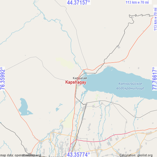
| Upper-left | 44.37157°, | 76.35992° |
| Center: | 43.86681°, | 77.06304° |
| Lower-right: | 43.35774°, | 77.76617° |
| Map W x H: | 112.7×112.7 km | = 70×70mi |
| max Lat: | 54.90596° ⇑80.7% North |
| Kapshagay: | 43.86681° |
| min Lat: | ⇓19.3% South 40.66338° |
| min Long | Kapshagay | max Long |
| 46.83361° | 77.06304° | 84.87144° |
| W 80.7%⇐ | ⇒19.3% E |
Elevation
Elevation of Kapshagay is 497 m = 1631 ft, and this is 140.5 m = 461 ft above average elevation for this country.
| Max E: |
1847 m = 6060 ft | 25.6% |
| Kapshagay | 497 m 1631 ft | |
| Avg. | 356.5 m = 1170 ft | |
Min E: |
-26 m = -85 ft | 74.4% |
See also: Kapshagay elevation on elevation.city.
Geographical zone
Kapshagay is located in North temperate zone (between Tropic of Cancer and the Arctic Circle). Distance of this Northern Tropic circle is 2271.6 km =1411.5 mi to South.| Distance of | km | miles | from Kapshagay |
|---|---|---|---|
| North Pole | 5129.5 | 3187.3 | to North |
| Arctic Circle | 2523.6 | 1568.1 | to North |
| Tropic Cancer | 2271.6 | 1411.5 | to South |
| Equator | 4877.5 | 3030.7 | to South |


Nearby cities:
15 places around Kapshagay: (largest is in red/bold)
• Almaty
68.7 km =42.7 mi,  189°
189°
• Bakanas
122.1 km =75.9 mi,  329°
329°
• Balpyk Bī
147.9 km =91.9 mi,  38°
38°
• Burunday
59.3 km =36.8 mi,  196°
196°
• Chemolgan
65 km =40.4 mi,  212°
212°
• Esik
65 km =40.4 mi,  151°
151°
• Kegen
197.9 km =123 mi,  118°
118°
• Otegen Batyra
49.9 km =31 mi,  183°
183°
• Pervomayka
55.7 km =34.6 mi, 190°
• Saryozek
91.1 km =56.6 mi,  52°
52°
• Taldykorgan
164.7 km =102.3 mi, 39°
• Talghar
64.3 km =40 mi,  167°
167°
• Tekeli
176.9 km =109.9 mi, 52°
• Turgen
67.1 km =41.7 mi,  140°
140°
• Ush-Tyube
170.3 km =105.8 mi,  25°
25°
Sources, notices
• [Note1] Compared only with cities in Kazakhstan existing in our database
• [Src1] Map data: © OpenStreetMap contributors (CC-BY-SA)
• [Src2] Other city data from geonames.org with taken over terms of usage.
• [Src3] Geographical zone / Annual Mean Temperature by Robert A. Rohde @ Wikipedia
