Kegen geodata
Kegen (Almaty Oblysy) is a populated place; located in Kazakhstan in Asia/Almaty (GMT+5) time zone. With population of 9,993 people, there are 112 cities with bigger population in this country. Compared to other cities in Kazakhstan, 90.4% of cities are located further ↑North; 86.7% of cities are located further ←West and 100% of cities have lower elevation than Kegen. Note1


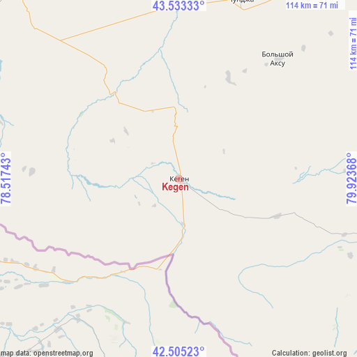
Kegen GPS coordinates[2]
43° 1' 17.148" North, 79° 13' 13.98" East
| Map corner | latitude | longitude |
|---|---|---|
| Upper-left | 43.53333°, | 78.51743° |
| Center: | 43.02143°, | 79.22055° |
| Lower-right: | 42.50523°, | 79.92368° |
| Map W x H: | 114.3×114.3 km | = 71×71mi |
| max Lat: | 54.90596° ⇑90.4% North |
| Kegen: | 43.02143° |
| min Lat: | ⇓9.6% South 40.66338° |
| min Long | Kegen | max Long |
| 46.83361° | 79.22055° | 84.87144° |
| W 86.7%⇐ | ⇒13.3% E |
Elevation
Elevation of Kegen is 1847 m = 6060 ft, and this is 1490.5 m = 4890 ft above average elevation for this country.
| Max E: |
1847 m = 6060 ft | 0% |
| Kegen | 1847 m 6060 ft | |
| Avg. | 356.5 m = 1170 ft | |
Min E: |
-26 m = -85 ft | 100% |
See also: Kazakhstan elevation on elevation.city.
Geographical zone
Kegen is located in North temperate zone (between Tropic of Cancer and the Arctic Circle). Distance of this Northern Tropic circle is 2177.6 km =1353.1 mi to South.| Distance of | km | miles | from Kegen |
|---|---|---|---|
| North Pole | 5223.5 | 3245.7 | to North |
| Arctic Circle | 2617.6 | 1626.5 | to North |
| Tropic Cancer | 2177.6 | 1353.1 | to South |
| Equator | 4783.5 | 2972.3 | to South |


Nearby cities:
15 places around Kegen: (largest is in red/bold)
• Almaty
187.8 km =116.7 mi,  278°
278°
• Balpyk Bī
223.6 km =138.9 mi,  339°
339°
• Burunday
195.4 km =121.4 mi, 280°
• Chemolgan
214.1 km =133 mi, 280°
• Esik
148.1 km =92 mi, 284°
• Kapshagay
197.9 km =123 mi,  298°
298°
• Narynkol
84.4 km =52.4 mi,  112°
112°
• Otegen Batyra
183.7 km =114.1 mi, 283°
• Pervomayka
189 km =117.4 mi, 281°
• Saryozek
179.6 km =111.6 mi,  326°
326°
• Taldykorgan
231.8 km =144 mi, 343°
• Talghar
163.6 km =101.7 mi, 281°
• Tekeli
203.9 km =126.7 mi,  351°
351°
• Turgen
138.4 km =86 mi,  287°
287°
• Zharkent
142.2 km =88.4 mi,  26°
26°
Sources, notices
• [Note1] Compared only with cities in Kazakhstan existing in our database
• [Src1] Map data: © OpenStreetMap contributors (CC-BY-SA)
• [Src2] Other city data from geonames.org with taken over terms of usage.
• [Src3] Geographical zone / Annual Mean Temperature by Robert A. Rohde @ Wikipedia
