Taldykorgan geodata
Taldykorgan (Almaty Oblysy) is a seat of a first-order administrative division; located in Kazakhstan in Asia/Almaty (GMT+5) time zone. With population of 116,558 people, there are 19 cities with bigger population in this country. Compared to other cities in Kazakhstan, 73% of cities are located further ↑North; 84.4% of cities are located further ←West and 82.6% of cities have lower elevation than Taldykorgan. Note1


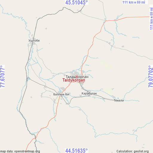
Taldykorgan GPS coordinates[2]
45° 0' 56.016" North, 78° 22' 26.004" East
| Map corner | latitude | longitude |
|---|---|---|
| Upper-left | 45.51045°, | 77.67077° |
| Center: | 45.01556°, | 78.37389° |
| Lower-right: | 44.51635°, | 79.07702° |
| Map W x H: | 110.5×110.5 km | = 68.7×68.7mi |
| max Lat: | 54.90596° ⇑73% North |
| Taldykorgan: | 45.01556° |
| min Lat: | ⇓27% South 40.66338° |
| min Long | Taldykorgan | max Long |
| 46.83361° | 78.37389° | 84.87144° |
| W 84.4%⇐ | ⇒15.6% E |
Elevation
Elevation of Taldykorgan is 596 m = 1955 ft, and this is 239.5 m = 786 ft above average elevation for this country.
| Max E: |
1847 m = 6060 ft | 17.4% |
| Taldykorgan | 596 m 1955 ft | |
| Avg. | 356.5 m = 1170 ft | |
Min E: |
-26 m = -85 ft | 82.6% |
See also: Taldykorgan elevation on elevation.city.
Geographical zone
Taldykorgan is located in North temperate zone (between Tropic of Cancer and the Arctic Circle). Distance of this North polar circle is 2395.9 km =1488.7 mi to North.| Distance of | km | miles | from Taldykorgan |
|---|---|---|---|
| North Pole | 5001.8 | 3108 | to North |
| Arctic Circle | 2395.9 | 1488.7 | to North |
| Tropic Cancer | 2399.3 | 1490.9 | to South |
| Equator | 5005.3 | 3110.1 | to South |


Nearby cities:
15 places around Taldykorgan: (largest is in red/bold)
• Bakanas
167.1 km =103.8 mi,  262°
262°
• Balpyk Bī
16.9 km =10.5 mi,  221°
221°
• Esik
198.7 km =123.5 mi,  201°
201°
• Kapshagay
164.7 km =102.3 mi, 219°
• Lepsy
142.7 km =88.7 mi,  18°
18°
• Matay
101.4 km =63 mi, 15°
• Molaly
48.8 km =30.3 mi,  354°
354°
• Otegen Batyra
207.7 km =129.1 mi,  211°
211°
• Sarkand
128.5 km =79.8 mi,  69°
69°
• Saryozek
79.3 km =49.3 mi, 203°
• Talghar
210.7 km =130.9 mi, 205°
• Tekeli
41.3 km =25.7 mi,  119°
119°
• Turgen
190 km =118.1 mi, 199°
• Ush-Tyube
40.6 km =25.2 mi,  310°
310°
• Zharkent
160.1 km =99.5 mi,  126°
126°
In other languages:
- In France: Taldykourgan
- In Italian: Taldıqorğan
- In Russian: Талдыкорган
- In Chinese: 塔爾迪庫爾干
Sources, notices
• [Note1] Compared only with cities in Kazakhstan existing in our database
• [Src1] Map data: © OpenStreetMap contributors (CC-BY-SA)
• [Src2] Other city data from geonames.org with taken over terms of usage.
• [Src3] Geographical zone / Annual Mean Temperature by Robert A. Rohde @ Wikipedia
