Almaty geodata
Almaty is a seat of a first-order administrative division; located in Kazakhstan in Asia/Almaty (GMT+5) time zone. With population of 2,000,900 people, there are 0 cities with bigger population in this country. Compared to other cities in Kazakhstan, 88.1% of cities are located further ↑North; 79.3% of cities are located further ←West and 94.4% of cities have lower elevation than Almaty. Note1


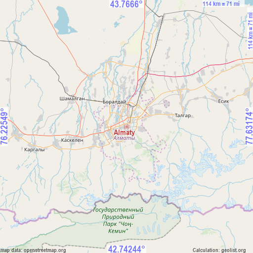
Almaty GPS coordinates[2]
43° 15' 24.012" North, 76° 55' 42.996" East
| Map corner | latitude | longitude |
|---|---|---|
| Upper-left | 43.7666°, | 76.22549° |
| Center: | 43.25667°, | 76.92861° |
| Lower-right: | 42.74244°, | 77.63174° |
| Map W x H: | 113.9×113.9 km | = 70.8×70.8mi |
| max Lat: | 54.90596° ⇑88.1% North |
| Almaty: | 43.25667° |
| min Lat: | ⇓11.9% South 40.66338° |
| min Long | Almaty | max Long |
| 46.83361° | 76.92861° | 84.87144° |
| W 79.3%⇐ | ⇒20.7% E |
Elevation
Elevation of Almaty is 787 m = 2582 ft, and this is 430.5 m = 1412 ft above average elevation for this country.
| Max E: |
1847 m = 6060 ft | 5.6% |
| Almaty | 787 m 2582 ft | |
| Avg. | 356.5 m = 1170 ft | |
Min E: |
-26 m = -85 ft | 94.4% |
See also: Almaty elevation on elevation.city.
Geographical zone
Almaty is located in North temperate zone (between Tropic of Cancer and the Arctic Circle). Distance of this Northern Tropic circle is 2203.8 km =1369.4 mi to South.| Distance of | km | miles | from Almaty |
|---|---|---|---|
| North Pole | 5197.4 | 3229.5 | to North |
| Arctic Circle | 2591.5 | 1610.3 | to North |
| Tropic Cancer | 2203.8 | 1369.4 | to South |
| Equator | 4809.7 | 2988.6 | to South |


Nearby cities:
15 places around Almaty: (largest is in red/bold)
• Bakanas
180.3 km =112 mi,  343°
343°
• Balpyk Bī
210.5 km =130.8 mi,  29°
29°
• Burunday
12.5 km =7.8 mi,  331°
331°
• Chemolgan
28 km =17.4 mi,  298°
298°
• Esik
43.8 km =27.2 mi,  75°
75°
• Georgiyevka
181.4 km =112.7 mi,  262°
262°
• Kapshagay
68.7 km =42.7 mi,  9°
9°
• Kegen
187.8 km =116.7 mi,  98°
98°
• Otegen Batyra
19.6 km =12.2 mi,  22°
22°
• Pervomayka
13 km =8.1 mi,  4°
4°
• Saryozek
148.7 km =92.4 mi, 34°
• Taldykorgan
227 km =141.1 mi, 30°
• Talghar
25.8 km =16 mi, 78°
• Tekeli
232 km =144.2 mi,  40°
40°
• Turgen
56.1 km =34.9 mi,  73°
73°
Sources, notices
• [Note1] Compared only with cities in Kazakhstan existing in our database
• [Src1] Map data: © OpenStreetMap contributors (CC-BY-SA)
• [Src2] Other city data from geonames.org with taken over terms of usage.
• [Src3] Geographical zone / Annual Mean Temperature by Robert A. Rohde @ Wikipedia
