Tekeli geodata
Tekeli (Almaty Oblysy) is a populated place; located in Kazakhstan in Asia/Almaty (GMT+5) time zone. With population of 26,678 people, there are 56 cities with bigger population in this country. Compared to other cities in Kazakhstan, 74.4% of cities are located further ↑North; 85.9% of cities are located further ←West and 99.3% of cities have lower elevation than Tekeli. Note1


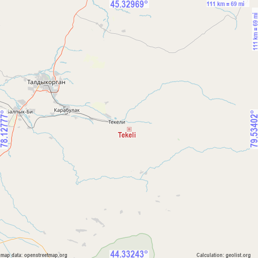
Tekeli GPS coordinates[2]
44° 49' 59.592" North, 78° 49' 51.204" East
| Map corner | latitude | longitude |
|---|---|---|
| Upper-left | 45.32969°, | 78.12777° |
| Center: | 44.83322°, | 78.83089° |
| Lower-right: | 44.33243°, | 79.53402° |
| Map W x H: | 110.9×110.9 km | = 68.9×68.9mi |
| max Lat: | 54.90596° ⇑74.4% North |
| Tekeli: | 44.83322° |
| min Lat: | ⇓25.6% South 40.66338° |
| min Long | Tekeli | max Long |
| 46.83361° | 78.83089° | 84.87144° |
| W 85.9%⇐ | ⇒14.1% E |
Elevation
Elevation of Tekeli is 1146 m = 3760 ft, and this is 789.5 m = 2590 ft above average elevation for this country.
| Max E: |
1847 m = 6060 ft | 0.7% |
| Tekeli | 1146 m 3760 ft | |
| Avg. | 356.5 m = 1170 ft | |
Min E: |
-26 m = -85 ft | 99.3% |
See also: Kazakhstan elevation on elevation.city.
Geographical zone
Tekeli is located in North temperate zone (between Tropic of Cancer and the Arctic Circle). Distance of this Northern Tropic circle is 2379.1 km =1478.3 mi to South.| Distance of | km | miles | from Tekeli |
|---|---|---|---|
| North Pole | 5022.1 | 3120.6 | to North |
| Arctic Circle | 2416.2 | 1501.4 | to North |
| Tropic Cancer | 2379.1 | 1478.3 | to South |
| Equator | 4985 | 3097.5 | to South |


Nearby cities:
15 places around Tekeli: (largest is in red/bold)
• Bakanas
201.8 km =125.4 mi,  269°
269°
• Balpyk Bī
47.8 km =29.7 mi,  279°
279°
• Esik
197.8 km =122.9 mi,  213°
213°
• Kapshagay
176.9 km =109.9 mi,  232°
232°
• Kegen
203.9 km =126.7 mi,  171°
171°
• Lepsy
156.1 km =97 mi,  3°
3°
• Matay
118.4 km =73.6 mi,  355°
355°
• Molaly
79.9 km =49.6 mi,  329°
329°
• Sarkand
106.6 km =66.2 mi,  52°
52°
• Saryozek
85.8 km =53.3 mi, 232°
• Taldykorgan
41.3 km =25.7 mi,  299°
299°
• Talghar
212.3 km =131.9 mi,  216°
216°
• Turgen
187.4 km =116.4 mi, 211°
• Ush-Tyube
81.5 km =50.6 mi, 304°
• Zharkent
119.1 km =74 mi,  128°
128°
Sources, notices
• [Note1] Compared only with cities in Kazakhstan existing in our database
• [Src1] Map data: © OpenStreetMap contributors (CC-BY-SA)
• [Src2] Other city data from geonames.org with taken over terms of usage.
• [Src3] Geographical zone / Annual Mean Temperature by Robert A. Rohde @ Wikipedia
