Otegen Batyra geodata
Otegen Batyra (Almaty Oblysy) is a populated place; located in Kazakhstan in Asia/Almaty (GMT+5) time zone. With population of 18,864 people, there are 69 cities with bigger population in this country. Compared to other cities in Kazakhstan, 84.8% of cities are located further ↑North; 80.4% of cities are located further ←West and 85.9% of cities have lower elevation than Otegen Batyra. Note1


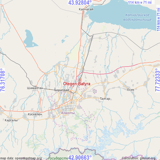
Otegen Batyra GPS coordinates[2]
43° 25' 10.164" North, 77° 1' 12.72" East
| Map corner | latitude | longitude |
|---|---|---|
| Upper-left | 43.92804°, | 76.31708° |
| Center: | 43.41949°, | 77.0202° |
| Lower-right: | 42.90663°, | 77.72333° |
| Map W x H: | 113.6×113.6 km | = 70.6×70.6mi |
| max Lat: | 54.90596° ⇑84.8% North |
| Otegen Batyra: | 43.41949° |
| min Lat: | ⇓15.2% South 40.66338° |
| min Long | Otegen Batyra | max Long |
| 46.83361° | 77.0202° | 84.87144° |
| W 80.4%⇐ | ⇒19.6% E |
Elevation
Elevation of Otegen Batyra is 643 m = 2110 ft, and this is 286.5 m = 940 ft above average elevation for this country.
| Max E: |
1847 m = 6060 ft | 14.1% |
| Otegen Batyra | 643 m 2110 ft | |
| Avg. | 356.5 m = 1170 ft | |
Min E: |
-26 m = -85 ft | 85.9% |
See also: Kazakhstan elevation on elevation.city.
Geographical zone
Otegen Batyra is located in North temperate zone (between Tropic of Cancer and the Arctic Circle). Distance of this Northern Tropic circle is 2221.9 km =1380.6 mi to South.| Distance of | km | miles | from Otegen Batyra |
|---|---|---|---|
| North Pole | 5179.3 | 3218.3 | to North |
| Arctic Circle | 2573.4 | 1599 | to North |
| Tropic Cancer | 2221.9 | 1380.6 | to South |
| Equator | 4827.8 | 2999.9 | to South |


Nearby cities:
15 places around Otegen Batyra: (largest is in red/bold)
• Almaty
19.6 km =12.2 mi,  202°
202°
• Bakanas
165.6 km =102.9 mi,  338°
338°
• Balpyk Bī
191.1 km =118.7 mi,  30°
30°
• Burunday
15.1 km =9.4 mi,  242°
242°
• Chemolgan
32.3 km =20.1 mi,  261°
261°
• Esik
35.7 km =22.2 mi,  101°
101°
• Georgiyevka
191.7 km =119.1 mi, 257°
• Kapshagay
49.9 km =31 mi,  3°
3°
• Kegen
183.7 km =114.1 mi, 103°
• Pervomayka
8.2 km =5.1 mi,  231°
231°
• Saryozek
129.6 km =80.5 mi,  36°
36°
• Taldykorgan
207.7 km =129.1 mi, 31°
• Talghar
22 km =13.7 mi,  125°
125°
• Tekeli
213.5 km =132.7 mi, 42°
• Turgen
46.3 km =28.8 mi,  92°
92°
Sources, notices
• [Note1] Compared only with cities in Kazakhstan existing in our database
• [Src1] Map data: © OpenStreetMap contributors (CC-BY-SA)
• [Src2] Other city data from geonames.org with taken over terms of usage.
• [Src3] Geographical zone / Annual Mean Temperature by Robert A. Rohde @ Wikipedia
