Burunday geodata
Burunday (Almaty Oblysy) is a populated place; located in Kazakhstan in Asia/Almaty (GMT+5) time zone. With population of 20,996 people, there are 64 cities with bigger population in this country. Compared to other cities in Kazakhstan, 86.3% of cities are located further ↑North; 78.5% of cities are located further ←West and 89.6% of cities have lower elevation than Burunday. Note1


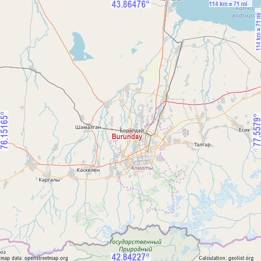
Burunday GPS coordinates[2]
43° 21' 20.412" North, 76° 51' 17.172" East
| Map corner | latitude | longitude |
|---|---|---|
| Upper-left | 43.86476°, | 76.15165° |
| Center: | 43.35567°, | 76.85477° |
| Lower-right: | 42.84227°, | 77.5579° |
| Map W x H: | 113.7×113.7 km | = 70.6×70.6mi |
| max Lat: | 54.90596° ⇑86.3% North |
| Burunday: | 43.35567° |
| min Lat: | ⇓13.7% South 40.66338° |
| min Long | Burunday | max Long |
| 46.83361° | 76.85477° | 84.87144° |
| W 78.5%⇐ | ⇒21.5% E |
Elevation
Elevation of Burunday is 689 m = 2260 ft, and this is 332.5 m = 1091 ft above average elevation for this country.
| Max E: |
1847 m = 6060 ft | 10.4% |
| Burunday | 689 m 2260 ft | |
| Avg. | 356.5 m = 1170 ft | |
Min E: |
-26 m = -85 ft | 89.6% |
See also: Kazakhstan elevation on elevation.city.
Geographical zone
Burunday is located in North temperate zone (between Tropic of Cancer and the Arctic Circle). Distance of this Northern Tropic circle is 2214.8 km =1376.2 mi to South.| Distance of | km | miles | from Burunday |
|---|---|---|---|
| North Pole | 5186.4 | 3222.7 | to North |
| Arctic Circle | 2580.5 | 1603.4 | to North |
| Tropic Cancer | 2214.8 | 1376.2 | to South |
| Equator | 4820.7 | 2995.4 | to South |


Nearby cities:
15 places around Burunday: (largest is in red/bold)
• Almaty
12.5 km =7.8 mi,  151°
151°
• Bakanas
168.1 km =104.5 mi,  343°
343°
• Balpyk Bī
204.1 km =126.8 mi,  32°
32°
• Chemolgan
18.7 km =11.6 mi,  277°
277°
• Esik
48.3 km =30 mi,  90°
90°
• Georgiyevka
177.1 km =110 mi,  258°
258°
• Kapshagay
59.3 km =36.8 mi,  16°
16°
• Kegen
195.4 km =121.4 mi,  100°
100°
• Otegen Batyra
15.1 km =9.4 mi,  62°
62°
• Pervomayka
7.2 km =4.5 mi,  73°
73°
• Saryozek
143.3 km =89 mi,  38°
38°
• Taldykorgan
220.7 km =137.1 mi, 33°
• Talghar
31.8 km =19.8 mi, 100°
• Tekeli
227.8 km =141.5 mi, 43°
• Turgen
59.9 km =37.2 mi, 85°
Sources, notices
• [Note1] Compared only with cities in Kazakhstan existing in our database
• [Src1] Map data: © OpenStreetMap contributors (CC-BY-SA)
• [Src2] Other city data from geonames.org with taken over terms of usage.
• [Src3] Geographical zone / Annual Mean Temperature by Robert A. Rohde @ Wikipedia
