Zharkent geodata
Zharkent (Almaty Oblysy) is a populated place; located in Kazakhstan in Asia/Almaty (GMT+5) time zone. With population of 34,422 people, there are 47 cities with bigger population in this country. Compared to other cities in Kazakhstan, 79.6% of cities are located further ↑North; 88.1% of cities are located further ←West and 85.6% of cities have lower elevation than Zharkent. Note1


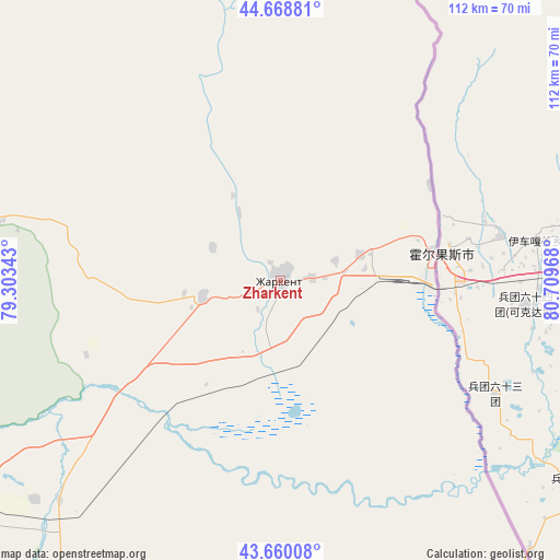
Zharkent GPS coordinates[2]
44° 9' 59.76" North, 80° 0' 23.58" East
| Map corner | latitude | longitude |
|---|---|---|
| Upper-left | 44.66881°, | 79.30343° |
| Center: | 44.1666°, | 80.00655° |
| Lower-right: | 43.66008°, | 80.70968° |
| Map W x H: | 112.2×112.2 km | = 69.7×69.7mi |
| max Lat: | 54.90596° ⇑79.6% North |
| Zharkent: | 44.1666° |
| min Lat: | ⇓20.4% South 40.66338° |
| min Long | Zharkent | max Long |
| 46.83361° | 80.00655° | 84.87144° |
| W 88.1%⇐ | ⇒11.9% E |
Elevation
Elevation of Zharkent is 636 m = 2087 ft, and this is 279.5 m = 917 ft above average elevation for this country.
| Max E: |
1847 m = 6060 ft | 14.4% |
| Zharkent | 636 m 2087 ft | |
| Avg. | 356.5 m = 1170 ft | |
Min E: |
-26 m = -85 ft | 85.6% |
See also: Kazakhstan elevation on elevation.city.
Geographical zone
Zharkent is located in North temperate zone (between Tropic of Cancer and the Arctic Circle). Distance of this Northern Tropic circle is 2304.9 km =1432.2 mi to South.| Distance of | km | miles | from Zharkent |
|---|---|---|---|
| North Pole | 5096.2 | 3166.6 | to North |
| Arctic Circle | 2490.3 | 1547.4 | to North |
| Tropic Cancer | 2304.9 | 1432.2 | to South |
| Equator | 4910.9 | 3051.5 | to South |


Nearby cities:
15 places around Zharkent: (largest is in red/bold)
• Balpyk Bī
162.7 km =101.1 mi,  300°
300°
• Druzhba
229.8 km =142.8 mi,  58°
58°
• Esik
224.1 km =139.2 mi,  246°
246°
• Kapshagay
237.7 km =147.7 mi,  261°
261°
• Kegen
142.2 km =88.4 mi,  206°
206°
• Matay
217.2 km =135 mi,  332°
332°
• Molaly
195.6 km =121.5 mi,  316°
316°
• Narynkol
160.7 km =99.9 mi,  175°
175°
• Sarkand
138.6 km =86.1 mi,  357°
357°
• Saryozek
163.4 km =101.5 mi,  277°
277°
• Taldykorgan
160.1 km =99.5 mi,  306°
306°
• Talghar
242 km =150.4 mi, 246°
• Tekeli
119.1 km =74 mi, 308°
• Turgen
211.6 km =131.5 mi, 246°
• Ush-Tyube
200.5 km =124.6 mi, 307°
Sources, notices
• [Note1] Compared only with cities in Kazakhstan existing in our database
• [Src1] Map data: © OpenStreetMap contributors (CC-BY-SA)
• [Src2] Other city data from geonames.org with taken over terms of usage.
• [Src3] Geographical zone / Annual Mean Temperature by Robert A. Rohde @ Wikipedia
