Narynkol geodata
Narynkol (Almaty Oblysy) is a seat of a second-order administrative division; located in Kazakhstan in Asia/Almaty (GMT+5) time zone. In our database, there are 268 cities with bigger population. Compared to other cities in Kazakhstan, 93.7% of cities are located further ↑North; 88.5% of cities are located further ←West and 99.6% of cities have lower elevation than Narynkol. Note1


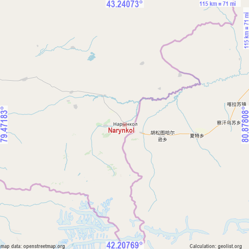
Narynkol GPS coordinates[2]
42° 43' 34.896" North, 80° 10' 29.82" East
| Map corner | latitude | longitude |
|---|---|---|
| Upper-left | 43.24073°, | 79.47183° |
| Center: | 42.72636°, | 80.17495° |
| Lower-right: | 42.20769°, | 80.87808° |
| Map W x H: | 114.9×114.9 km | = 71.4×71.4mi |
| max Lat: | 54.90596° ⇑93.7% North |
| Narynkol: | 42.72636° |
| min Lat: | ⇓6.3% South 40.66338° |
| min Long | Narynkol | max Long |
| 46.83361° | 80.17495° | 84.87144° |
| W 88.5%⇐ | ⇒11.5% E |
Elevation
Elevation of Narynkol is 1817 m = 5961 ft, and this is 1460.5 m = 4792 ft above average elevation for this country.
| Max E: |
1847 m = 6060 ft | 0.40000000000001% |
| Narynkol | 1817 m 5961 ft | |
| Avg. | 356.5 m = 1170 ft | |
Min E: |
-26 m = -85 ft | 99.6% |
See also: Kazakhstan elevation on elevation.city.
Geographical zone
Narynkol is located in North temperate zone (between Tropic of Cancer and the Arctic Circle). Distance of this Northern Tropic circle is 2144.8 km =1332.7 mi to South.| Distance of | km | miles | from Narynkol |
|---|---|---|---|
| North Pole | 5256.3 | 3266.1 | to North |
| Arctic Circle | 2650.4 | 1646.9 | to North |
| Tropic Cancer | 2144.8 | 1332.7 | to South |
| Equator | 4750.7 | 2951.9 | to South |


Nearby cities:
15 places around Narynkol: (largest is in red/bold)
• Almaty
270.5 km =168.1 mi,  282°
282°
• Balpyk Bī
287.8 km =178.8 mi,  327°
327°
• Burunday
278.7 km =173.2 mi, 284°
• Chemolgan
297.4 km =184.8 mi, 284°
• Esik
232 km =144.2 mi,  287°
287°
• Kapshagay
281.9 km =175.2 mi,  296°
296°
• Kegen
84.4 km =52.4 mi, 292°
• Otegen Batyra
267.6 km =166.3 mi, 286°
• Pervomayka
272.5 km =169.3 mi, 285°
• Saryozek
254.1 km =157.9 mi,  315°
315°
• Taldykorgan
292.6 km =181.8 mi, 330°
• Talghar
247 km =153.5 mi, 285°
• Tekeli
257.9 km =160.3 mi,  335°
335°
• Turgen
222.7 km =138.4 mi, 289°
• Zharkent
160.7 km =99.9 mi,  355°
355°
Sources, notices
• [Note1] Compared only with cities in Kazakhstan existing in our database
• [Src1] Map data: © OpenStreetMap contributors (CC-BY-SA)
• [Src2] Other city data from geonames.org with taken over terms of usage.
• [Src3] Geographical zone / Annual Mean Temperature by Robert A. Rohde @ Wikipedia
