Afgooye geodata
Afgooye (Lower Shabeelle) is a seat of a second-order administrative division; located in Somalia in Africa/Mogadishu (GMT+3) time zone. With population of 65,461 people, there are 9 cities with bigger population in this country. Compared to other cities in Somalia, 81.1% of cities are located further ↑North; 52.8% of cities are located further →East and 56.6% of cities have higher elevation than Afgooye. Note1


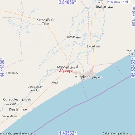
Afgooye GPS coordinates[2]
2° 8' 17.16" North, 45° 7' 16.32" East
| Map corner | latitude | longitude |
|---|---|---|
| Upper-left | 2.84056°, | 44.41808° |
| Center: | 2.1381°, | 45.1212° |
| Lower-right: | 1.43532°, | 45.82433° |
| Map W x H: | 156.2×156.3 km | = 97.1×97.1mi |
| max Lat: | 11.96611° ⇑81.1% North |
| Afgooye: | 2.1381° |
| min Lat: | ⇓18.9% South -1.21917° |
| min Long | Afgooye | max Long |
| 41.83725° | 45.1212° | 51.0773° |
| W 47.2%⇐ | ⇒52.8% E |
Elevation
Elevation of Afgooye is 87 m = 285 ft, and this is 202.9 m = 666 ft below average elevation for this country.
| Max E: |
1786 m = 5860 ft | 56.6% |
| Avg. | 289.9 m = 951 ft | |
| Afgooye | 87 m = 285 ft | |
Min E: |
-2 m = -7 ft | 43.4% |
See also: Afgooye elevation on elevation.city.
Geographical zone
Afgooye is located in North Torrid zone (between Equator and Tropic of Cancer). Distance of Equator is 237.7 km =147.7 mi to South.| Distance of | km | miles | from Afgooye |
|---|---|---|---|
| North Pole | 9769.3 | 6070.4 | to North |
| Arctic Circle | 7163.4 | 4451.1 | to North |
| Tropic Cancer | 2368.2 | 1471.5 | to North |
| Equator | 237.7 | 147.7 | to South |


Nearby cities:
15 places around Afgooye: (largest is in red/bold)
• Baidoa
196.2 km =121.9 mi,  303°
303°
• Beledweyne
289 km =179.6 mi,  1°
1°
• Buulobarde
197.1 km =122.5 mi,  14°
14°
• Buurhakaba
137.4 km =85.4 mi, 302°
• Cadale
150.3 km =93.4 mi,  62°
62°
• Jalalaqsi
147.6 km =91.7 mi,  21°
21°
• Jawhar
83 km =51.6 mi,  30°
30°
• Mahaddayweyne
103.5 km =64.3 mi, 26°
• Marka
60.9 km =37.8 mi,  219°
219°
• Mogadishu
27.2 km =16.9 mi,  114°
114°
• Qoryooley
76.4 km =47.5 mi,  239°
239°
• Tayeeglow
219.8 km =136.6 mi,  342°
342°
• Waajid
279.1 km =173.4 mi,  311°
311°
• Wanlaweyn
59.1 km =36.7 mi,  334°
334°
• Xuddur
259.5 km =161.2 mi, 328°
Sources, notices
• [Note1] Compared only with cities in Somalia existing in our database
• [Src1] Map data: © OpenStreetMap contributors (CC-BY-SA)
• [Src2] Other city data from geonames.org with taken over terms of usage.
• [Src3] Geographical zone / Annual Mean Temperature by Robert A. Rohde @ Wikipedia
