Luuq geodata
Luuq (Gedo) is a populated place; located in Somalia in Africa/Mogadishu (GMT+3) time zone. With population of 33,820 people, there are 19 cities with bigger population in this country. Compared to other cities in Somalia, 62.3% of cities are located further ↑North; 92.5% of cities are located further →East and 54.7% of cities have lower elevation than Luuq. Note1


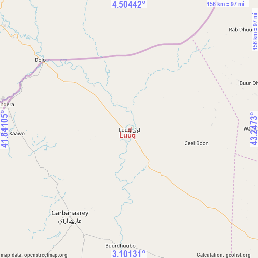
Luuq GPS coordinates[2]
3° 48' 11.34" North, 42° 32' 39.012" East
| Map corner | latitude | longitude |
|---|---|---|
| Upper-left | 4.50442°, | 41.84105° |
| Center: | 3.80315°, | 42.54417° |
| Lower-right: | 3.10131°, | 43.2473° |
| Map W x H: | 156×156 km | = 96.9×96.9mi |
| max Lat: | 11.96611° ⇑62.3% North |
| Luuq: | 3.80315° |
| min Lat: | ⇓37.7% South -1.21917° |
| min Long | Luuq | max Long |
| 41.83725° | 42.54417° | 51.0773° |
| W 7.5%⇐ | ⇒92.5% E |
Elevation
Elevation of Luuq is 150 m = 492 ft, and this is 139.9 m = 459 ft below average elevation for this country.
| Max E: |
1786 m = 5860 ft | 45.3% |
| Avg. | 289.9 m = 951 ft | |
| Luuq | 150 m = 492 ft | |
Min E: |
-2 m = -7 ft | 54.7% |
See also: Somalia elevation on elevation.city.
Geographical zone
Luuq is located in North Torrid zone (between Equator and Tropic of Cancer). Distance of Equator is 422.9 km =262.8 mi to South.| Distance of | km | miles | from Luuq |
|---|---|---|---|
| North Pole | 9584.2 | 5955.3 | to North |
| Arctic Circle | 6978.3 | 4336.1 | to North |
| Tropic Cancer | 2183 | 1356.5 | to North |
| Equator | 422.9 | 262.8 | to South |


Nearby cities:
15 places around Luuq: (largest is in red/bold)
• Baardheere
164.9 km =102.5 mi,  190°
190°
• Baidoa
144.7 km =89.9 mi,  121°
121°
• Beledweyne
312.6 km =194.2 mi,  70°
70°
• Buulobarde
335.5 km =208.5 mi,  89°
89°
• Buurhakaba
203.4 km =126.4 mi, 123°
• Bu’aale
302.4 km =187.9 mi,  179°
179°
• Dujuuma
283.6 km =176.2 mi, 179°
• Garbahaarrey
63.8 km =39.6 mi,  214°
214°
• Qoryooley
314.4 km =195.4 mi,  135°
135°
• Saacow
242.1 km =150.4 mi, 182°
• Tayeeglow
219.5 km =136.4 mi,  83°
83°
• Waajid
77.9 km =48.4 mi, 89°
• Wanlaweyn
292.2 km =181.6 mi, 116°
• Xuddur
153.4 km =95.3 mi, 76°
• Yeed
99.2 km =61.6 mi,  33°
33°
Sources, notices
• [Note1] Compared only with cities in Somalia existing in our database
• [Src1] Map data: © OpenStreetMap contributors (CC-BY-SA)
• [Src2] Other city data from geonames.org with taken over terms of usage.
• [Src3] Geographical zone / Annual Mean Temperature by Robert A. Rohde @ Wikipedia
