Mogadishu geodata
Mogadishu (Banaadir) is a capital of a political entity; located in Somalia in Africa/Mogadishu (GMT+3) time zone. With population of 2,587,183 people, there are 0 cities with bigger population in this country. Compared to other cities in Somalia, 83% of cities are located further ↑North; 50.9% of cities are located further ←West and 79.2% of cities have higher elevation than Mogadishu. Note1


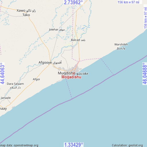
Mogadishu GPS coordinates[2]
2° 2' 13.596" North, 45° 20' 37.5" East
| Map corner | latitude | longitude |
|---|---|---|
| Upper-left | 2.73962°, | 44.64063° |
| Center: | 2.03711°, | 45.34375° |
| Lower-right: | 1.33429°, | 46.04688° |
| Map W x H: | 156.3×156.3 km | = 97.1×97.1mi |
| max Lat: | 11.96611° ⇑83% North |
| Mogadishu: | 2.03711° |
| min Lat: | ⇓17% South -1.21917° |
| min Long | Mogadishu | max Long |
| 41.83725° | 45.34375° | 51.0773° |
| W 50.9%⇐ | ⇒49.1% E |
Elevation
Elevation of Mogadishu is 12 m = 39 ft, and this is 277.9 m = 912 ft below average elevation for this country.
| Max E: |
1786 m = 5860 ft | 79.2% |
| Avg. | 289.9 m = 951 ft | |
| Mogadishu | 12 m = 39 ft | |
Min E: |
-2 m = -7 ft | 20.8% |
See also: Mogadishu elevation on elevation.city.
Geographical zone
Mogadishu is located in North Torrid zone (between Equator and Tropic of Cancer). Distance of Equator is 226.5 km =140.7 mi to South.| Distance of | km | miles | from Mogadishu |
|---|---|---|---|
| North Pole | 9780.6 | 6077.4 | to North |
| Arctic Circle | 7174.7 | 4458.2 | to North |
| Tropic Cancer | 2379.4 | 1478.5 | to North |
| Equator | 226.5 | 140.7 | to South |


Nearby cities:
15 places around Mogadishu: (largest is in red/bold)
• Afgooye
27.2 km =16.9 mi,  294°
294°
• Baidoa
223 km =138.6 mi,  302°
302°
• Beledweyne
300.5 km =186.7 mi,  357°
357°
• Buulobarde
203.5 km =126.4 mi,  7°
7°
• Buurhakaba
164.4 km =102.2 mi, 301°
• Cadale
135.2 km =84 mi,  53°
53°
• Ceeldheer
286.7 km =178.1 mi, 45°
• Jalalaqsi
151.6 km =94.2 mi, 10°
• Jawhar
84.5 km =52.5 mi, 11°
• Mahaddayweyne
106.2 km =66 mi, 11°
• Marka
72.9 km =45.3 mi,  240°
240°
• Qoryooley
94.6 km =58.8 mi,  252°
252°
• Tayeeglow
239 km =148.5 mi,  337°
337°
• Wanlaweyn
81.7 km =50.8 mi,  322°
322°
• Xuddur
282.4 km =175.5 mi,  325°
325°
In other languages:
- In Spanish: Mogadiscio
- In France: Mogadiscio
- In German: Mogadischu
- In Italian: Mogadiscio
- In Russian: Могадишо
- In Chinese: 摩加迪休
Sources, notices
• [Note1] Compared only with cities in Somalia existing in our database
• [Src1] Map data: © OpenStreetMap contributors (CC-BY-SA)
• [Src2] Other city data from geonames.org with taken over terms of usage.
• [Src3] Geographical zone / Annual Mean Temperature by Robert A. Rohde @ Wikipedia
