Qoryooley geodata
Qoryooley (Lower Shabeelle) is a seat of a second-order administrative division; located in Somalia in Africa/Mogadishu (GMT+3) time zone. With population of 51,720 people, there are 14 cities with bigger population in this country. Compared to other cities in Somalia, 84.9% of cities are located further ↑North; 62.3% of cities are located further →East and 58.5% of cities have higher elevation than Qoryooley. Note1


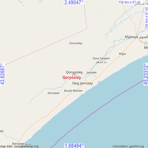
Qoryooley GPS coordinates[2]
1° 47' 16.224" North, 44° 31' 47.964" East
| Map corner | latitude | longitude |
|---|---|---|
| Upper-left | 2.49047°, | 43.82687° |
| Center: | 1.78784°, | 44.52999° |
| Lower-right: | 1.08494°, | 45.23312° |
| Map W x H: | 156.3×156.3 km | = 97.1×97.1mi |
| max Lat: | 11.96611° ⇑84.9% North |
| Qoryooley: | 1.78784° |
| min Lat: | ⇓15.1% South -1.21917° |
| min Long | Qoryooley | max Long |
| 41.83725° | 44.52999° | 51.0773° |
| W 37.7%⇐ | ⇒62.3% E |
Elevation
Elevation of Qoryooley is 69 m = 226 ft, and this is 220.9 m = 725 ft below average elevation for this country.
| Max E: |
1786 m = 5860 ft | 58.5% |
| Avg. | 289.9 m = 951 ft | |
| Qoryooley | 69 m = 226 ft | |
Min E: |
-2 m = -7 ft | 41.5% |
See also: Qoryooley elevation on elevation.city.
Geographical zone
Qoryooley is located in North Torrid zone (between Equator and Tropic of Cancer). Distance of Equator is 198.8 km =123.5 mi to South.| Distance of | km | miles | from Qoryooley |
|---|---|---|---|
| North Pole | 9808.3 | 6094.6 | to North |
| Arctic Circle | 7202.4 | 4475.4 | to North |
| Tropic Cancer | 2407.1 | 1495.7 | to North |
| Equator | 198.8 | 123.5 | to South |


Nearby cities:
15 places around Qoryooley: (largest is in red/bold)
• Afgooye
76.4 km =47.5 mi,  59°
59°
• Baidoa
176.9 km =109.9 mi,  326°
326°
• Buurhakaba
123.5 km =76.7 mi,  336°
336°
• Bu’aale
230.1 km =143 mi,  250°
250°
• Cadale
226.6 km =140.8 mi, 61°
• Dujuuma
225.4 km =140.1 mi, 254°
• Jalalaqsi
212.9 km =132.3 mi,  33°
33°
• Jawhar
154.3 km =95.9 mi,  44°
44°
• Jilib
241.9 km =150.3 mi,  233°
233°
• Mahaddayweyne
172.7 km =107.3 mi, 40°
• Marka
28 km =17.4 mi,  106°
106°
• Mogadishu
94.6 km =58.8 mi,  72°
72°
• Saacow
232.9 km =144.7 mi,  265°
265°
• Tayeeglow
248.1 km =154.2 mi,  359°
359°
• Wanlaweyn
100.8 km =62.6 mi,  23°
23°
Sources, notices
• [Note1] Compared only with cities in Somalia existing in our database
• [Src1] Map data: © OpenStreetMap contributors (CC-BY-SA)
• [Src2] Other city data from geonames.org with taken over terms of usage.
• [Src3] Geographical zone / Annual Mean Temperature by Robert A. Rohde @ Wikipedia
