Marka geodata
Marka (Lower Shabeelle) is a seat of a first-order administrative division; located in Somalia in Africa/Mogadishu (GMT+3) time zone. With population of 230,100 people, there are 4 cities with bigger population in this country. Compared to other cities in Somalia, 86.8% of cities are located further ↑North; 60.4% of cities are located further →East and 79.2% of cities have higher elevation than Marka. Note1


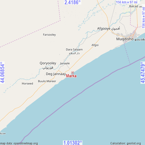
Marka GPS coordinates[2]
1° 42' 57.384" North, 44° 46' 17.976" East
| Map corner | latitude | longitude |
|---|---|---|
| Upper-left | 2.4186°, | 44.06854° |
| Center: | 1.71594°, | 44.77166° |
| Lower-right: | 1.01302°, | 45.47479° |
| Map W x H: | 156.3×156.3 km | = 97.1×97.1mi |
| max Lat: | 11.96611° ⇑86.8% North |
| Marka: | 1.71594° |
| min Lat: | ⇓13.2% South -1.21917° |
| min Long | Marka | max Long |
| 41.83725° | 44.77166° | 51.0773° |
| W 39.6%⇐ | ⇒60.4% E |
Elevation
Elevation of Marka is 12 m = 39 ft, and this is 277.9 m = 912 ft below average elevation for this country.
| Max E: |
1786 m = 5860 ft | 79.2% |
| Avg. | 289.9 m = 951 ft | |
| Marka | 12 m = 39 ft | |
Min E: |
-2 m = -7 ft | 20.8% |
See also: Marka elevation on elevation.city.
Geographical zone
Marka is located in North Torrid zone (between Equator and Tropic of Cancer). Distance of Equator is 190.8 km =118.6 mi to South.| Distance of | km | miles | from Marka |
|---|---|---|---|
| North Pole | 9816.3 | 6099.6 | to North |
| Arctic Circle | 7210.4 | 4480.3 | to North |
| Tropic Cancer | 2415.1 | 1500.7 | to North |
| Equator | 190.8 | 118.6 | to South |


Nearby cities:
15 places around Marka: (largest is in red/bold)
• Afgooye
60.9 km =37.8 mi,  39°
39°
• Baidoa
199.2 km =123.8 mi,  321°
321°
• Buulobarde
253.6 km =157.6 mi,  20°
20°
• Buurhakaba
143.3 km =89 mi,  327°
327°
• Bu’aale
253.2 km =157.3 mi,  253°
253°
• Cadale
207.8 km =129.1 mi,  56°
56°
• Dujuuma
249.7 km =155.2 mi,  258°
258°
• Jalalaqsi
206.3 km =128.2 mi,  26°
26°
• Jawhar
143.4 km =89.1 mi, 34°
• Mahaddayweyne
163.4 km =101.5 mi, 31°
• Mogadishu
72.9 km =45.3 mi, 60°
• Qoryooley
28 km =17.4 mi,  286°
286°
• Saacow
259.3 km =161.1 mi,  267°
267°
• Tayeeglow
257.7 km =160.1 mi,  353°
353°
• Wanlaweyn
101.3 km =62.9 mi,  7°
7°
Sources, notices
• [Note1] Compared only with cities in Somalia existing in our database
• [Src1] Map data: © OpenStreetMap contributors (CC-BY-SA)
• [Src2] Other city data from geonames.org with taken over terms of usage.
• [Src3] Geographical zone / Annual Mean Temperature by Robert A. Rohde @ Wikipedia
