Gwembe geodata
Gwembe (Southern) is a populated place; located in Zambia in Africa/Lusaka (GMT+2) time zone. With population of 2,052 people, there are 65 cities with bigger population in this country. Compared to other cities in Zambia, 90.9% of cities are located further ↑North; 66.7% of cities are located further →East and 63.6% of cities have lower elevation than Gwembe. Note1


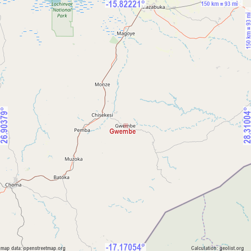
Gwembe GPS coordinates[2]
16° 29' 51.18" South, 27° 36' 24.876" East
| Map corner | latitude | longitude |
|---|---|---|
| Upper-left | -15.82221°, | 26.90379° |
| Center: | -16.49755°, | 27.60691° |
| Lower-right: | -17.17054°, | 28.31004° |
| Map W x H: | 149.9×149.9 km | = 93.1×93.1mi |
| max Lat: | -8.46887° ⇑90.9% North |
| Gwembe: | -16.49755° |
| min Lat: | ⇓9.1% South -17.84194° |
| min Long | Gwembe | max Long |
| 22.67926° | 27.60691° | 33.1782° |
| W 33.3%⇐ | ⇒66.7% E |
Elevation
Elevation of Gwembe is 1247 m = 4091 ft, and this is 103.6 m = 340 ft above average elevation for this country.
| Max E: |
1622 m = 5322 ft | 36.4% |
| Gwembe | 1247 m 4091 ft | |
| Avg. | 1143.4 m = 3751 ft | |
Min E: |
328 m = 1076 ft | 63.6% |
See also: Zambia elevation on elevation.city.
Geographical zone
Gwembe is located in South Torrid zone (between Equator and Tropic of Capricorn). Distance of this Southern Tropic circle is 771.6 km =479.4 mi to South.| Distance of | km | miles | from Gwembe |
|---|---|---|---|
| Equator | 1834.4 | 1139.8 | to North |
| Tropic Capricorn | 771.6 | 479.4 | to South |
| Antarctic Circle | 5566.8 | 3459 | to South |
| South Pole | 8172.7 | 5078.3 | to South |


Nearby cities:
15 places around Gwembe: (largest is in red/bold)
• Chibombo
210.6 km =130.9 mi,  13°
13°
• Choma
74.5 km =46.3 mi,  242°
242°
• Chongwe
173.5 km =107.8 mi,  41°
41°
• Kabwe
245.1 km =152.3 mi,  21°
21°
• Kafue
101.6 km =63.1 mi, 37°
• Livingstone
238.8 km =148.4 mi,  231°
231°
• Lusaka
141.4 km =87.9 mi,  30°
30°
• Maamba
108.2 km =67.2 mi,  206°
206°
• Mazabuka
72.9 km =45.3 mi, 11°
• Monze
27.2 km =16.9 mi,  331°
331°
• Mumbwa
178.2 km =110.7 mi,  340°
340°
• Nakambala
76.2 km =47.3 mi, 14°
• Namwala
149.9 km =93.1 mi,  303°
303°
• Siavonga
117.5 km =73 mi,  92°
92°
• Sinazongwe
86.3 km =53.6 mi,  190°
190°
Sources, notices
• [Note1] Compared only with cities in Zambia existing in our database
• [Src1] Map data: © OpenStreetMap contributors (CC-BY-SA)
• [Src2] Other city data from geonames.org with taken over terms of usage.
• [Src3] Geographical zone / Annual Mean Temperature by Robert A. Rohde @ Wikipedia
