Choma geodata
Choma (Southern) is a seat of a first-order administrative division; located in Zambia in Africa/Lusaka (GMT+2) time zone. With population of 46,746 people, there are 15 cities with bigger population in this country. Compared to other cities in Zambia, 93.9% of cities are located further ↑North; 74.2% of cities are located further →East and 78.8% of cities have lower elevation than Choma. Note1


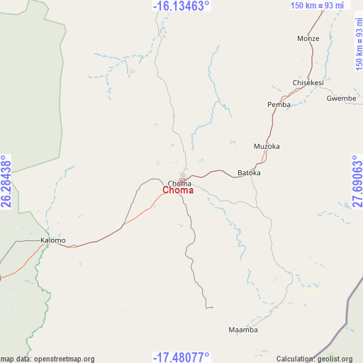
Choma GPS coordinates[2]
16° 48' 32.004" South, 26° 59' 15" East
| Map corner | latitude | longitude |
|---|---|---|
| Upper-left | -16.13463°, | 26.28438° |
| Center: | -16.80889°, | 26.9875° |
| Lower-right: | -17.48077°, | 27.69063° |
| Map W x H: | 149.7×149.7 km | = 93×93mi |
| max Lat: | -8.46887° ⇑93.9% North |
| Choma: | -16.80889° |
| min Lat: | ⇓6.1% South -17.84194° |
| min Long | Choma | max Long |
| 22.67926° | 26.9875° | 33.1782° |
| W 25.8%⇐ | ⇒74.2% E |
Elevation
Elevation of Choma is 1317 m = 4321 ft, and this is 173.6 m = 570 ft above average elevation for this country.
| Max E: |
1622 m = 5322 ft | 21.2% |
| Choma | 1317 m 4321 ft | |
| Avg. | 1143.4 m = 3751 ft | |
Min E: |
328 m = 1076 ft | 78.8% |
See also: Choma elevation on elevation.city.
Geographical zone
Choma is located in South Torrid zone (between Equator and Tropic of Capricorn). Distance of this Southern Tropic circle is 736.9 km =457.9 mi to South.| Distance of | km | miles | from Choma |
|---|---|---|---|
| Equator | 1869 | 1161.3 | to North |
| Tropic Capricorn | 736.9 | 457.9 | to South |
| Antarctic Circle | 5532.2 | 3437.5 | to South |
| South Pole | 8138.1 | 5056.8 | to South |


Nearby cities:
15 places around Choma: (largest is in red/bold)
• Chibombo
265.9 km =165.2 mi,  25°
25°
• Chongwe
244.6 km =152 mi,  47°
47°
• Gwembe
74.5 km =46.3 mi,  62°
62°
• Kafue
172 km =106.9 mi, 47°
• Livingstone
166.3 km =103.3 mi,  226°
226°
• Lusaka
208.8 km =129.7 mi,  41°
41°
• Maamba
64.4 km =40 mi,  164°
164°
• Mazabuka
133.5 km =83 mi, 37°
• Monze
78.8 km =49 mi, 42°
• Mumbwa
203.2 km =126.3 mi,  2°
2°
• Nakambala
137.6 km =85.5 mi, 37°
• Namwala
131.5 km =81.7 mi,  333°
333°
• Sesheke
295.3 km =183.5 mi,  255°
255°
• Siavonga
185.8 km =115.5 mi,  80°
80°
• Sinazongwe
71.2 km =44.2 mi,  134°
134°
Sources, notices
• [Note1] Compared only with cities in Zambia existing in our database
• [Src1] Map data: © OpenStreetMap contributors (CC-BY-SA)
• [Src2] Other city data from geonames.org with taken over terms of usage.
• [Src3] Geographical zone / Annual Mean Temperature by Robert A. Rohde @ Wikipedia
