Livingstone geodata
Livingstone (Southern) is a seat of a second-order administrative division; located in Zambia in Africa/Lusaka (GMT+2) time zone. With population of 109,203 people, there are 7 cities with bigger population in this country. Compared to other cities in Zambia, 100% of cities are located further ↑North; 80.3% of cities are located further →East and 83.3% of cities have higher elevation than Livingstone. Note1


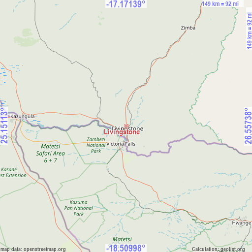
Livingstone GPS coordinates[2]
17° 50' 30.984" South, 25° 51' 15.3" East
| Map corner | latitude | longitude |
|---|---|---|
| Upper-left | -17.17139°, | 25.15113° |
| Center: | -17.84194°, | 25.85425° |
| Lower-right: | -18.50998°, | 26.55738° |
| Map W x H: | 148.8×148.8 km | = 92.5×92.5mi |
| max Lat: | -8.46887° ⇑100% North |
| Livingstone: | -17.84194° |
| min Lat: | ⇓0% South -17.84194° |
| min Long | Livingstone | max Long |
| 22.67926° | 25.85425° | 33.1782° |
| W 19.7%⇐ | ⇒80.3% E |
Elevation
Elevation of Livingstone is 969 m = 3179 ft, and this is 174.4 m = 572 ft below average elevation for this country.
| Max E: |
1622 m = 5322 ft | 83.3% |
| Avg. | 1143.4 m = 3751 ft | |
| Livingstone | 969 m = 3179 ft | |
Min E: |
328 m = 1076 ft | 16.7% |
See also: Livingstone elevation on elevation.city.
Geographical zone
Livingstone is located in South Torrid zone (between Equator and Tropic of Capricorn). Distance of this Southern Tropic circle is 622.1 km =386.6 mi to South.| Distance of | km | miles | from Livingstone |
|---|---|---|---|
| Equator | 1983.8 | 1232.7 | to North |
| Tropic Capricorn | 622.1 | 386.6 | to South |
| Antarctic Circle | 5417.3 | 3366.2 | to South |
| South Pole | 8023.2 | 4985.4 | to South |


Nearby cities:
15 places around Livingstone: (largest is in red/bold)
• Choma
166.3 km =103.3 mi,  46°
46°
• Gwembe
238.8 km =148.4 mi, 51°
• Kafue
338.3 km =210.2 mi, 47°
• Kaoma
358.2 km =222.6 mi,  341°
341°
• Lusaka
374.8 km =232.9 mi,  43°
43°
• Maamba
147.1 km =91.4 mi,  68°
68°
• Mazabuka
298.9 km =185.7 mi, 42°
• Monze
245 km =152.2 mi, 44°
• Mumbwa
343 km =213.1 mi,  22°
22°
• Nakambala
303.2 km =188.4 mi, 42°
• Namwala
240.7 km =149.6 mi,  14°
14°
• Senanga
335.4 km =208.4 mi,  304°
304°
• Sesheke
170 km =105.6 mi,  283°
283°
• Siavonga
336.1 km =208.8 mi,  64°
64°
• Sinazongwe
182.2 km =113.2 mi, 69°
Sources, notices
• [Note1] Compared only with cities in Zambia existing in our database
• [Src1] Map data: © OpenStreetMap contributors (CC-BY-SA)
• [Src2] Other city data from geonames.org with taken over terms of usage.
• [Src3] Geographical zone / Annual Mean Temperature by Robert A. Rohde @ Wikipedia
