Kalulushi geodata
Kalulushi (Copperbelt) is a populated place; located in Zambia in Africa/Lusaka (GMT+2) time zone. With population of 66,575 people, there are 10 cities with bigger population in this country. Compared to other cities in Zambia, 59.1% of cities are located further ↓South; 56.1% of cities are located further →East and 72.7% of cities have lower elevation than Kalulushi. Note1


Kalulushi GPS coordinates[2]
12° 50' 29.436" South, 28° 5' 41.244" East
| Map corner | latitude | longitude |
|---|---|---|
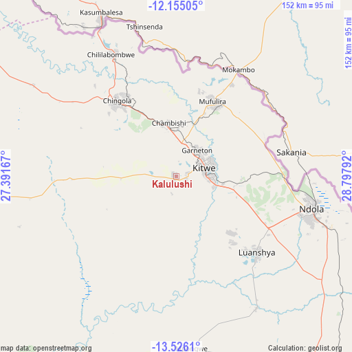
| Upper-left | -12.15505°, | 27.39167° |
| Center: | -12.84151°, | 28.09479° |
| Lower-right: | -13.5261°, | 28.79792° |
| Map W x H: | 152.4×152.4 km | = 94.7×94.7mi |
| max Lat: | -8.46887° ⇑40.9% North |
| Kalulushi: | -12.84151° |
| min Lat: | ⇓59.1% South -17.84194° |
| min Long | Kalulushi | max Long |
| 22.67926° | 28.09479° | 33.1782° |
| W 43.9%⇐ | ⇒56.1% E |
Elevation
Elevation of Kalulushi is 1304 m = 4278 ft, and this is 160.6 m = 527 ft above average elevation for this country.
| Max E: |
1622 m = 5322 ft | 27.3% |
| Kalulushi | 1304 m 4278 ft | |
| Avg. | 1143.4 m = 3751 ft | |
Min E: |
328 m = 1076 ft | 72.7% |
See also: Kalulushi elevation on elevation.city.
Geographical zone
Kalulushi is located in South Torrid zone (between Equator and Tropic of Capricorn). Distance of this Southern Tropic circle is 1178.1 km =732 mi to South.| Distance of | km | miles | from Kalulushi |
|---|---|---|---|
| Equator | 1427.8 | 887.2 | to North |
| Tropic Capricorn | 1178.1 | 732 | to South |
| Antarctic Circle | 5973.3 | 3711.6 | to South |
| South Pole | 8579.2 | 5330.9 | to South |


Nearby cities:
15 places around Kalulushi: (largest is in red/bold)
• Chambishi
23.7 km =14.7 mi,  349°
349°
• Chibombo
201.9 km =125.5 mi,  180°
180°
• Chililabombwe
60.7 km =37.7 mi,  330°
330°
• Chingola
41.6 km =25.8 mi, 326°
• Kabwe
182.5 km =113.4 mi,  167°
167°
• Kansanshi
199.2 km =123.8 mi,  294°
294°
• Kapiri Mposhi
140.2 km =87.1 mi,  153°
153°
• Kitwe
13.6 km =8.5 mi,  71°
71°
• Luanshya
47.9 km =29.8 mi,  133°
133°
• Mansa
202.2 km =125.6 mi,  25°
25°
• Mkushi
165.1 km =102.6 mi,  121°
121°
• Mpongwe
74.5 km =46.3 mi, 174°
• Mufulira
36.1 km =22.4 mi, 26°
• Ndola
60.1 km =37.3 mi,  102°
102°
• Solwezi
199.7 km =124.1 mi, 292°
Sources, notices
• [Note1] Compared only with cities in Zambia existing in our database
• [Src1] Map data: © OpenStreetMap contributors (CC-BY-SA)
• [Src2] Other city data from geonames.org with taken over terms of usage.
• [Src3] Geographical zone / Annual Mean Temperature by Robert A. Rohde @ Wikipedia
