Chambishi geodata
Chambishi (Copperbelt) is a populated place; located in Zambia in Africa/Lusaka (GMT+2) time zone. With population of 11,073 people, there are 38 cities with bigger population in this country. Compared to other cities in Zambia, 62.1% of cities are located further ↓South; 59.1% of cities are located further →East and 72.7% of cities have lower elevation than Chambishi. Note1


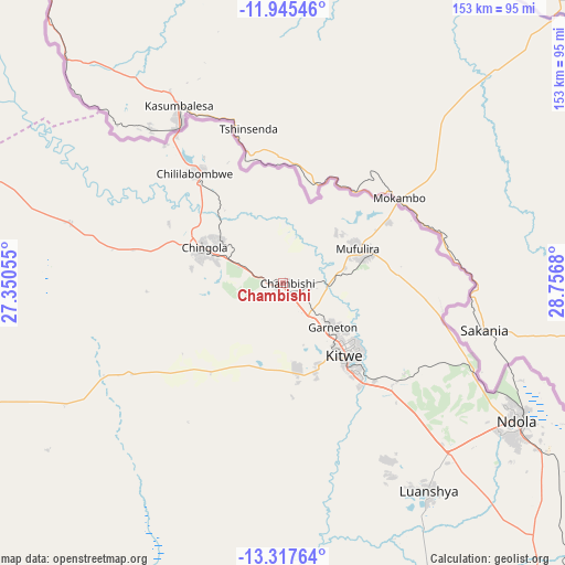
Chambishi GPS coordinates[2]
12° 37' 56.892" South, 28° 3' 13.212" East
| Map corner | latitude | longitude |
|---|---|---|
| Upper-left | -11.94546°, | 27.35055° |
| Center: | -12.63247°, | 28.05367° |
| Lower-right: | -13.31764°, | 28.7568° |
| Map W x H: | 152.6×152.6 km | = 94.8×94.8mi |
| max Lat: | -8.46887° ⇑37.9% North |
| Chambishi: | -12.63247° |
| min Lat: | ⇓62.1% South -17.84194° |
| min Long | Chambishi | max Long |
| 22.67926° | 28.05367° | 33.1782° |
| W 40.9%⇐ | ⇒59.1% E |
Elevation
Elevation of Chambishi is 1304 m = 4278 ft, and this is 160.6 m = 527 ft above average elevation for this country.
| Max E: |
1622 m = 5322 ft | 27.3% |
| Chambishi | 1304 m 4278 ft | |
| Avg. | 1143.4 m = 3751 ft | |
Min E: |
328 m = 1076 ft | 72.7% |
See also: Zambia elevation on elevation.city.
Geographical zone
Chambishi is located in South Torrid zone (between Equator and Tropic of Capricorn). Distance of this Southern Tropic circle is 1201.3 km =746.5 mi to South.| Distance of | km | miles | from Chambishi |
|---|---|---|---|
| Equator | 1404.6 | 872.8 | to North |
| Tropic Capricorn | 1201.3 | 746.5 | to South |
| Antarctic Circle | 5996.6 | 3726.1 | to South |
| South Pole | 8602.5 | 5345.3 | to South |


Nearby cities:
15 places around Chambishi: (largest is in red/bold)
• Chililabombwe
38.9 km =24.2 mi,  319°
319°
• Chingola
21.7 km =13.5 mi,  301°
301°
• Kabwe
206.2 km =128.1 mi,  168°
168°
• Kalulushi
23.7 km =14.7 mi, 169°
• Kansanshi
186.5 km =115.9 mi,  288°
288°
• Kapiri Mposhi
163.1 km =101.3 mi,  155°
155°
• Kataba
205.6 km =127.8 mi,  66°
66°
• Kitwe
25.6 km =15.9 mi,  137°
137°
• Luanshya
68.5 km =42.6 mi, 144°
• Mansa
183.7 km =114.1 mi,  29°
29°
• Mkushi
182 km =113.1 mi,  127°
127°
• Mpongwe
98.1 km =61 mi, 173°
• Mufulira
22.3 km =13.9 mi, 65°
• Ndola
72.9 km =45.3 mi,  119°
119°
• Solwezi
187.9 km =116.8 mi, 285°
Sources, notices
• [Note1] Compared only with cities in Zambia existing in our database
• [Src1] Map data: © OpenStreetMap contributors (CC-BY-SA)
• [Src2] Other city data from geonames.org with taken over terms of usage.
• [Src3] Geographical zone / Annual Mean Temperature by Robert A. Rohde @ Wikipedia
