Mufulira geodata
Mufulira (Copperbelt) is a populated place; located in Zambia in Africa/Lusaka (GMT+2) time zone. With population of 120,500 people, there are 5 cities with bigger population in this country. Compared to other cities in Zambia, 63.6% of cities are located further ↓South; 50% of cities are located further ←West and 69.7% of cities have lower elevation than Mufulira. Note1


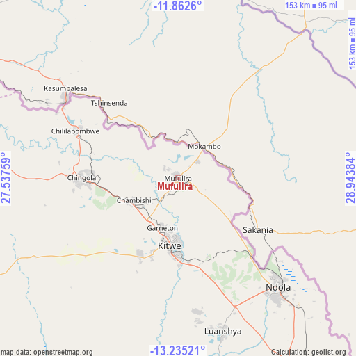
Mufulira GPS coordinates[2]
12° 32' 59.352" South, 28° 14' 26.556" East
| Map corner | latitude | longitude |
|---|---|---|
| Upper-left | -11.8626°, | 27.53759° |
| Center: | -12.54982°, | 28.24071° |
| Lower-right: | -13.23521°, | 28.94384° |
| Map W x H: | 152.6×152.6 km | = 94.8×94.8mi |
| max Lat: | -8.46887° ⇑36.4% North |
| Mufulira: | -12.54982° |
| min Lat: | ⇓63.6% South -17.84194° |
| min Long | Mufulira | max Long |
| 22.67926° | 28.24071° | 33.1782° |
| W 50%⇐ | ⇒50% E |
Elevation
Elevation of Mufulira is 1285 m = 4216 ft, and this is 141.6 m = 465 ft above average elevation for this country.
| Max E: |
1622 m = 5322 ft | 30.3% |
| Mufulira | 1285 m 4216 ft | |
| Avg. | 1143.4 m = 3751 ft | |
Min E: |
328 m = 1076 ft | 69.7% |
See also: Mufulira elevation on elevation.city.
Geographical zone
Mufulira is located in South Torrid zone (between Equator and Tropic of Capricorn). Distance of this Southern Tropic circle is 1210.5 km =752.2 mi to South.| Distance of | km | miles | from Mufulira |
|---|---|---|---|
| Equator | 1395.4 | 867.1 | to North |
| Tropic Capricorn | 1210.5 | 752.2 | to South |
| Antarctic Circle | 6005.8 | 3731.8 | to South |
| South Pole | 8611.7 | 5351.1 | to South |


Nearby cities:
15 places around Mufulira: (largest is in red/bold)
• Chambishi
22.3 km =13.9 mi,  245°
245°
• Chililabombwe
49.8 km =30.9 mi,  294°
294°
• Chingola
38.8 km =24.1 mi,  273°
273°
• Kalulushi
36.1 km =22.4 mi,  206°
206°
• Kansanshi
203.4 km =126.4 mi,  284°
284°
• Kapiri Mposhi
164.8 km =102.4 mi,  163°
163°
• Kataba
183.3 km =113.9 mi,  66°
66°
• Kitwe
28.2 km =17.5 mi,  186°
186°
• Luanshya
68 km =42.3 mi, 163°
• Mansa
166.1 km =103.2 mi,  25°
25°
• Mkushi
172.5 km =107.2 mi,  133°
133°
• Mpongwe
107.1 km =66.5 mi,  184°
184°
• Ndola
62.5 km =38.8 mi,  136°
136°
• Samfya
194.5 km =120.9 mi,  47°
47°
• Solwezi
205.5 km =127.7 mi, 281°
Sources, notices
• [Note1] Compared only with cities in Zambia existing in our database
• [Src1] Map data: © OpenStreetMap contributors (CC-BY-SA)
• [Src2] Other city data from geonames.org with taken over terms of usage.
• [Src3] Geographical zone / Annual Mean Temperature by Robert A. Rohde @ Wikipedia
