Kitwe geodata
Kitwe (Copperbelt) is a populated place; located in Zambia in Africa/Lusaka (GMT+2) time zone. With population of 400,914 people, there is 1 city with bigger population in this country. Compared to other cities in Zambia, 60.6% of cities are located further ↓South; 51.5% of cities are located further →East and 59.1% of cities have lower elevation than Kitwe. Note1


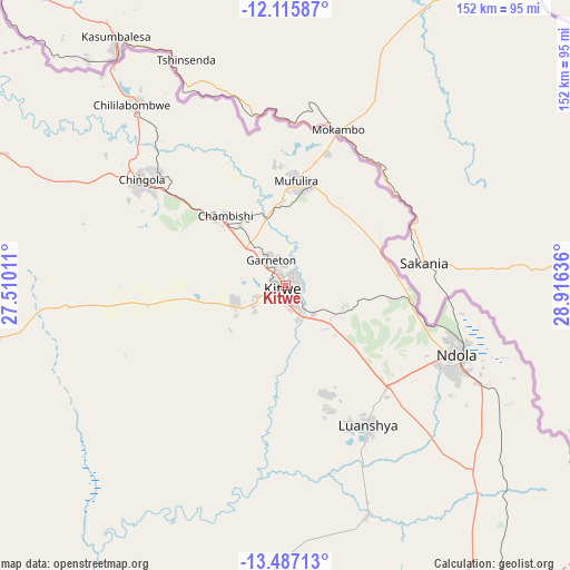
Kitwe GPS coordinates[2]
12° 48' 8.748" South, 28° 12' 47.628" East
| Map corner | latitude | longitude |
|---|---|---|
| Upper-left | -12.11587°, | 27.51011° |
| Center: | -12.80243°, | 28.21323° |
| Lower-right: | -13.48713°, | 28.91636° |
| Map W x H: | 152.5×152.5 km | = 94.8×94.8mi |
| max Lat: | -8.46887° ⇑39.4% North |
| Kitwe: | -12.80243° |
| min Lat: | ⇓60.6% South -17.84194° |
| min Long | Kitwe | max Long |
| 22.67926° | 28.21323° | 33.1782° |
| W 48.5%⇐ | ⇒51.5% E |
Elevation
Elevation of Kitwe is 1224 m = 4016 ft, and this is 80.6 m = 264 ft above average elevation for this country.
| Max E: |
1622 m = 5322 ft | 40.9% |
| Kitwe | 1224 m 4016 ft | |
| Avg. | 1143.4 m = 3751 ft | |
Min E: |
328 m = 1076 ft | 59.1% |
See also: Kitwe elevation on elevation.city.
Geographical zone
Kitwe is located in South Torrid zone (between Equator and Tropic of Capricorn). Distance of this Southern Tropic circle is 1182.4 km =734.7 mi to South.| Distance of | km | miles | from Kitwe |
|---|---|---|---|
| Equator | 1423.5 | 884.5 | to North |
| Tropic Capricorn | 1182.4 | 734.7 | to South |
| Antarctic Circle | 5977.7 | 3714.4 | to South |
| South Pole | 8583.6 | 5333.6 | to South |


Nearby cities:
15 places around Kitwe: (largest is in red/bold)
• Chambishi
25.6 km =15.9 mi,  317°
317°
• Chibombo
206.8 km =128.5 mi,  184°
184°
• Chililabombwe
64.5 km =40.1 mi, 318°
• Chingola
46.9 km =29.1 mi,  310°
310°
• Kabwe
184.6 km =114.7 mi,  172°
172°
• Kalulushi
13.6 km =8.5 mi,  251°
251°
• Kansanshi
209.3 km =130.1 mi,  292°
292°
• Kapiri Mposhi
139.1 km =86.4 mi,  159°
159°
• Kataba
198.8 km =123.5 mi,  59°
59°
• Luanshya
43.2 km =26.8 mi,  149°
149°
• Mansa
193 km =119.9 mi,  22°
22°
• Mkushi
156.8 km =97.4 mi,  125°
125°
• Mpongwe
78.8 km =49 mi, 184°
• Mufulira
28.2 km =17.5 mi,  6°
6°
• Ndola
49.1 km =30.5 mi,  110°
110°
Sources, notices
• [Note1] Compared only with cities in Zambia existing in our database
• [Src1] Map data: © OpenStreetMap contributors (CC-BY-SA)
• [Src2] Other city data from geonames.org with taken over terms of usage.
• [Src3] Geographical zone / Annual Mean Temperature by Robert A. Rohde @ Wikipedia
