Ndola geodata
Ndola (Copperbelt) is a seat of a first-order administrative division; located in Zambia in Africa/Lusaka (GMT+2) time zone. With population of 394,518 people, there are 2 cities with bigger population in this country. Compared to other cities in Zambia, 57.6% of cities are located further ↓South; 56.1% of cities are located further ←West and 75.8% of cities have lower elevation than Ndola. Note1


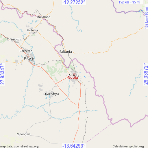
Ndola GPS coordinates[2]
12° 57' 31.212" South, 28° 38' 11.724" East
| Map corner | latitude | longitude |
|---|---|---|
| Upper-left | -12.27252°, | 27.93347° |
| Center: | -12.95867°, | 28.63659° |
| Lower-right: | -13.64293°, | 29.33972° |
| Map W x H: | 152.4×152.4 km | = 94.7×94.7mi |
| max Lat: | -8.46887° ⇑42.4% North |
| Ndola: | -12.95867° |
| min Lat: | ⇓57.6% South -17.84194° |
| min Long | Ndola | max Long |
| 22.67926° | 28.63659° | 33.1782° |
| W 56.1%⇐ | ⇒43.9% E |
Elevation
Elevation of Ndola is 1307 m = 4288 ft, and this is 163.6 m = 537 ft above average elevation for this country.
| Max E: |
1622 m = 5322 ft | 24.2% |
| Ndola | 1307 m 4288 ft | |
| Avg. | 1143.4 m = 3751 ft | |
Min E: |
328 m = 1076 ft | 75.8% |
See also: Ndola elevation on elevation.city.
Geographical zone
Ndola is located in South Torrid zone (between Equator and Tropic of Capricorn). Distance of this Southern Tropic circle is 1165 km =723.9 mi to South.| Distance of | km | miles | from Ndola |
|---|---|---|---|
| Equator | 1440.9 | 895.3 | to North |
| Tropic Capricorn | 1165 | 723.9 | to South |
| Antarctic Circle | 5960.3 | 3703.6 | to South |
| South Pole | 8566.2 | 5322.8 | to South |


Nearby cities:
15 places around Ndola: (largest is in red/bold)
• Chambishi
72.9 km =45.3 mi,  299°
299°
• Chibombo
198.5 km =123.3 mi,  197°
197°
• Chililabombwe
110.2 km =68.5 mi,  306°
306°
• Chingola
94.6 km =58.8 mi, 300°
• Kabwe
166.7 km =103.6 mi,  187°
187°
• Kalulushi
60.1 km =37.3 mi,  282°
282°
• Kapiri Mposhi
112.7 km =70 mi,  178°
178°
• Kataba
172.6 km =107.2 mi,  46°
46°
• Kitwe
49.1 km =30.5 mi,  290°
290°
• Luanshya
31 km =19.3 mi,  230°
230°
• Mansa
197.6 km =122.8 mi,  8°
8°
• Mkushi
110.1 km =68.4 mi,  131°
131°
• Mpongwe
80.4 km =50 mi,  220°
220°
• Mufulira
62.5 km =38.8 mi,  316°
316°
• Serenje
175.8 km =109.2 mi,  99°
99°
Sources, notices
• [Note1] Compared only with cities in Zambia existing in our database
• [Src1] Map data: © OpenStreetMap contributors (CC-BY-SA)
• [Src2] Other city data from geonames.org with taken over terms of usage.
• [Src3] Geographical zone / Annual Mean Temperature by Robert A. Rohde @ Wikipedia
