Nyimba geodata
Nyimba (Eastern) is a populated place; located in Zambia in Africa/Lusaka (GMT+2) time zone. With population of 1,336 people, there are 66 cities with bigger population in this country. Compared to other cities in Zambia, 66.7% of cities are located further ↑North; 80.3% of cities are located further ←West and 95.5% of cities have higher elevation than Nyimba. Note1


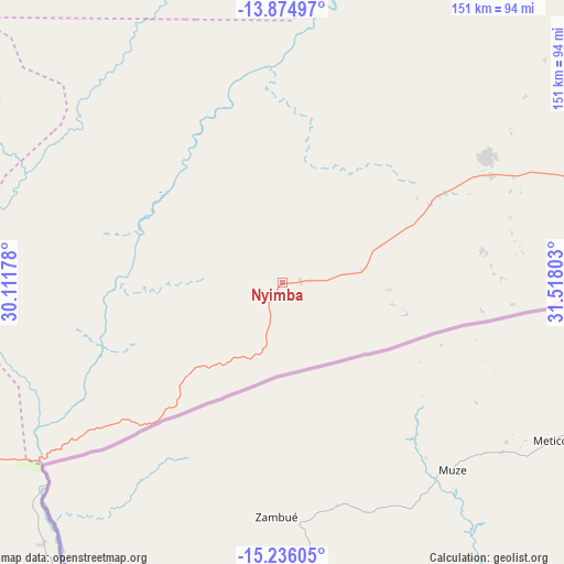
Nyimba GPS coordinates[2]
14° 33' 23.616" South, 30° 48' 53.64" East
| Map corner | latitude | longitude |
|---|---|---|
| Upper-left | -13.87497°, | 30.11178° |
| Center: | -14.55656°, | 30.8149° |
| Lower-right: | -15.23605°, | 31.51803° |
| Map W x H: | 151.3×151.3 km | = 94×94mi |
| max Lat: | -8.46887° ⇑66.7% North |
| Nyimba: | -14.55656° |
| min Lat: | ⇓33.3% South -17.84194° |
| min Long | Nyimba | max Long |
| 22.67926° | 30.8149° | 33.1782° |
| W 80.3%⇐ | ⇒19.7% E |
Elevation
Elevation of Nyimba is 716 m = 2349 ft, and this is 427.4 m = 1402 ft below average elevation for this country.
| Max E: |
1622 m = 5322 ft | 95.5% |
| Avg. | 1143.4 m = 3751 ft | |
| Nyimba | 716 m = 2349 ft | |
Min E: |
328 m = 1076 ft | 4.5% |
See also: Zambia elevation on elevation.city.
Geographical zone
Nyimba is located in South Torrid zone (between Equator and Tropic of Capricorn). Distance of this Southern Tropic circle is 987.4 km =613.5 mi to South.| Distance of | km | miles | from Nyimba |
|---|---|---|---|
| Equator | 1618.5 | 1005.7 | to North |
| Tropic Capricorn | 987.4 | 613.5 | to South |
| Antarctic Circle | 5782.6 | 3593.1 | to South |
| South Pole | 8388.5 | 5212.4 | to South |


Nearby cities:
15 places around Nyimba: (largest is in red/bold)
• Chadiza
183.2 km =113.8 mi,  72°
72°
• Chibombo
295.5 km =183.6 mi,  267°
267°
• Chipata
222.9 km =138.5 mi,  62°
62°
• Chongwe
244.7 km =152 mi,  249°
249°
• Kabwe
255.2 km =158.6 mi, 272°
• Kapiri Mposhi
240.1 km =149.2 mi,  285°
285°
• Luangwa
125.4 km =77.9 mi,  199°
199°
• Luanshya
303.2 km =188.4 mi,  301°
301°
• Lusaka
287.5 km =178.6 mi, 250°
• Mkushi
185.3 km =115.1 mi, 304°
• Mpika
310.5 km =192.9 mi,  12°
12°
• Mpongwe
309.7 km =192.4 mi, 292°
• Ndola
294.8 km =183.2 mi,  307°
307°
• Petauke
64.7 km =40.2 mi, 57°
• Serenje
160 km =99.4 mi,  336°
336°
Sources, notices
• [Note1] Compared only with cities in Zambia existing in our database
• [Src1] Map data: © OpenStreetMap contributors (CC-BY-SA)
• [Src2] Other city data from geonames.org with taken over terms of usage.
• [Src3] Geographical zone / Annual Mean Temperature by Robert A. Rohde @ Wikipedia
